 Brickell Tailor Alteration Shop Finder: First Work Suit Fit
Neighborhood Guides

Heritage Historic District Miami: 3 Morningside Layers
Explore Morningside from public sidewalks in Miami, reading planted streets, rooflines and small facade details without entering private homes or gardens.
Morningside rewards a visitor who looks beyond individual houses. On this Miami heritage historic district walk, the space between the pavement and the front wall matters as much as a decorated doorway. The city's preservation account identifies landscape design as part of the neighborhood's historical significance. Use that idea to shape an exterior visit: read the planted street as a designed setting, then notice how buildings sit within it. The route proposed here is a slow public-sidewalk study, with no house visits or promise of access to the bay.
The suburb was sold as a finished setting
The name Bay Shore belongs to the neighborhood's development story. The city's designation report describes subdivision phases undertaken by the Bay Shore Investment Company between 1922 and 1924, under its president James H. Nunnally. Streets, utilities and planting were part of the proposition offered to buyers. That distinction changes the architectural question. Instead of asking only which house is the oldest, ask how the surrounding infrastructure helped make a new residential district legible as a coherent place.
A subdivision drawing can make the process look instantaneous: lines appear, parcels are numbered, and a neighborhood seems complete. Walking introduces the missing space between those lines. Curbs, verges, paths and front gardens occupy different layers. A useful first exercise is to draw a single cross-section from the road to a house, using plain rectangles rather than botanical or architectural terminology. Mark the sidewalk separately from the garden. The diagram should clarify which parts of the scene are shared circulation and which remain private.
Begin with the long view between trees
Choose a legal place to pause where the public pavement offers an unobstructed view along the street. Let the trees interrupt the buildings. A roof may appear between branches while the rest of a house disappears behind planting. That incomplete view is part of the experience, rather than a photographic problem to solve by stepping onto a lawn. Compare the spaces between trunks with the apparent spacing of frontages. The two rhythms may reinforce each other or pull your eye in different directions.
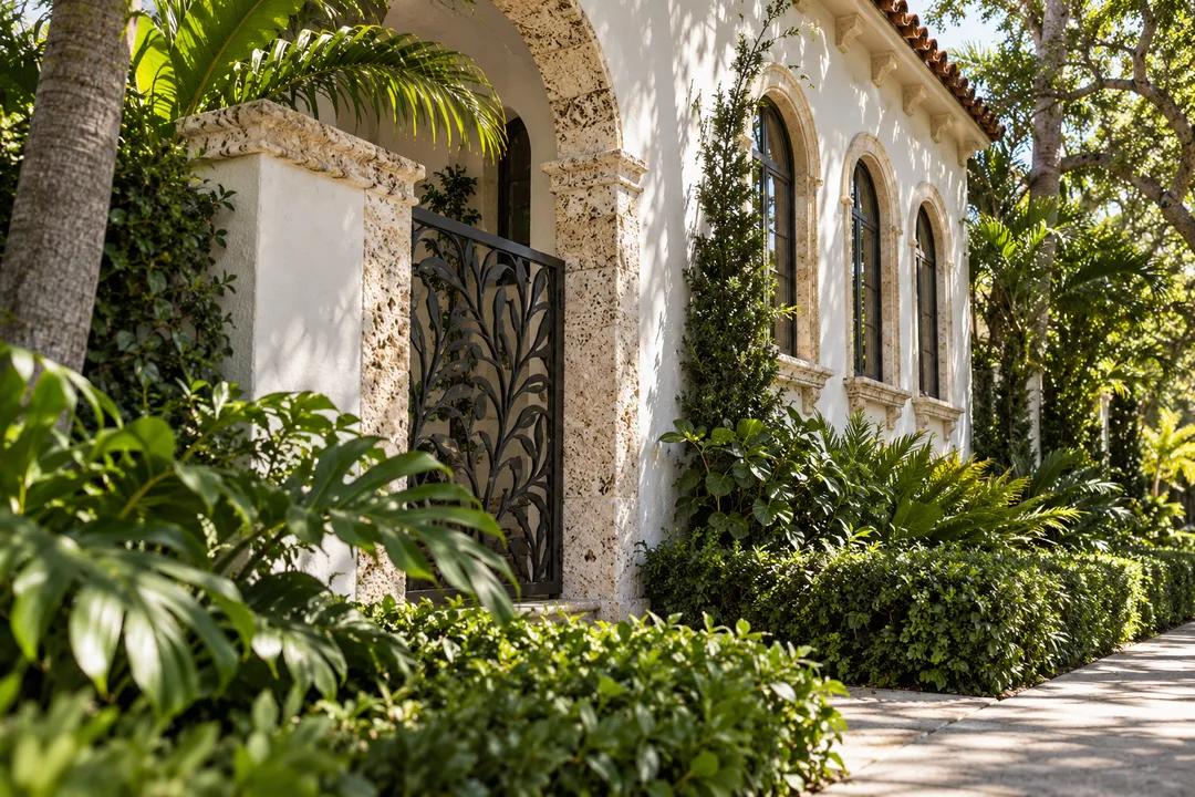
The official district account emphasizes broad, planted boulevards. Translate that description into a question about depth. Can you distinguish road, planted strip, pavement, front garden and wall as separate bands? Where one layer is obscured, leave a gap in your sketch. Do not assume that a continuous green surface is publicly accessible. The goal is to understand the composition from where pedestrians belong, rather than to reconstruct a property boundary from landscaping alone.
Street trees also change the scale of what you notice. A broad canopy can make a modest house feel like one element in a larger outdoor room. A more exposed frontage directs attention toward windows and roof edges. Try both readings before choosing a favorite building. If you are walking with a companion, one person can describe the whole streetscape while the other concentrates on a single frontage. Comparing those accounts reveals how much the setting contributes to the impression of architectural unity.
A roofline becomes the second layer
Morningside contains Mediterranean Revival, Art Deco and vernacular houses, according to the city. The mixture is useful because a planted setting does not require uniform architecture. Look for differences in outline: a sloping roof, a parapet, a projecting entrance, a broad low volume. Describe the visible shape before assigning a style. A tile roof is an observation. Calling every tile-roofed house Mediterranean Revival requires more evidence than that one feature provides.
Keep the landscape in the frame as you compare. A roof partially hidden by foliage may appear lower than a neighboring roof that is fully exposed. Position and vegetation affect the reading. Move only along the public route to obtain a second angle, then note whether the apparent difference persists. This is a small but useful distinction between noticing a shape and making a claim about a building's dimensions. Neither a quick glance nor a phone photograph measures height reliably.
For a short visit, choose one contrasting pair instead of collecting a long list of houses. One might present a strong roof silhouette while another relies on the arrangement of windows across a wall. Explain how each is encountered through the planting. That comparison produces a more specific memory than a sequence of attractive facades. It also avoids treating the neighborhood as an outdoor catalogue in which every property needs a label before the walk can count as successful.
The small detail should answer the big view
After the street and roofline, bring your attention to a detail visible without approaching a house. It might be the shadow inside an opening, the edge of an eave, or the relationship between a screen and the wall behind it. Choose something that explains the larger composition you have just studied. An entrance hidden behind foliage, for example, can make the roof and upper windows carry more of the building's public presence.
A close view does not need to produce a restoration verdict. Paint, replacement components and changing planting can all affect the image, but they cannot be dated accurately by appearance alone. Keep your notes descriptive: a dark recess, a light wall, a screen set back from the street. If a feature is too distant to resolve, leave it unresolved. A good exterior walk can end with a precise question rather than an invented answer about who designed or altered a particular house.
Practical Notes: make the landscape the destination
Use the city's Morningside map to choose the part of the district you want to study. The municipal overview places it generally between Biscayne Boulevard and Biscayne Bay, around NE 55th through NE 60th Streets. That broad description is orientation, not a parcel-level boundary. Keep the visit on public routes and choose crossings deliberately. A residential street is still a working street, with driveways and daily routines that deserve room.
Plan a short out-and-back rather than making the waterfront an obligatory finish. This article does not include Morningside Park's shoreline or promise that a baywalk is accessible. The architectural subject is already present in the relationship between streets, planting and homes. Carry drinking water, allow pauses outside the pedestrian flow, and stop before heat turns an attentive walk into an endurance task. No private garden is a necessary stop on this itinerary.
You can use Karpo APP as a starting point for a separate neighborhood search after the walk. Keep your own note about the district's defining relationship: landscape first, roofline second, detail third. The images accompanying this article are AI-generated architectural composites, not photographs of identified Morningside properties. They illustrate ways of seeing a planted residential setting. The actual walk is an opportunity to notice the differences that any composite inevitably leaves out.
Ask Karpo for more information.
Keep reading
- Brickell Tailor Alteration Shop Finder: First Work Suit Fit
 Coconut Grove Tailor Alteration Shop Finder: Heat-Proof Fits
 Little Havana Tailor Alteration Shop Finder: Guayabera Fits