 Bloomsbury Mews Walk Planner: Literary Brick Passages
Neighborhood Guides

Free Shoreditch Historic Neighborhood Photo Walk in 2 Hours
A Shoreditch historic neighborhood photo walk is free and links Redchurch Street, the 1900 Boundary Estate bandstand and Spitalfields' 1720s Fournier Street.
Shoreditch rewards photographers who ignore its most famous walls. A historic neighborhood photo walk here, free and fully on public streets, starts on Redchurch Street, climbs to the bandstand at Arnold Circus in the Boundary Estate, formally opened in 1900, and ends among the 1720s silk weavers' houses of Fournier Street. Allow about two hours, set off at 9am, and you will cover two centuries of East London housing in under three kilometres.
Start on Redchurch Street's Victorian Workshops
Redchurch Street runs east from Shoreditch High Street station and still keeps the scale of its industrial past: three and four storey Victorian brick buildings that once held workshops and warehouses, now with shopfronts at street level. Look up rather than ahead. Loading doors on upper floors, cast-iron hoist beams, faded painted lettering and patched brickwork tell the story far better than the polished ground floors, and they stay in the same place from one year to the next.
Street art in this part of Shoreditch changes constantly, sometimes within days, so treat any mural as a bonus rather than a fixed stop. A more reliable technique is to pair old and new in one frame: a hand-painted ghost sign above, a fresh paste-up below, or a Victorian chimney stack rising behind a modern shutter. That juxtaposition is what makes the neighbourhood visually distinct from the polished Georgian streets of the West End.
Before heading north, consider a short detour up Shoreditch High Street to St Leonard's Church, rebuilt in the 1730s to a design by George Dance the Elder. Its tall steeple is the one the nursery rhyme Oranges and Lemons refers to with the line about the bells of Shoreditch. Frame it from the far side of the junction with a longer lens, letting the traffic lights and bus stops sit low in the picture as modern counterpoint.
Calvert Avenue and the Boundary Estate
Turn north up Calvert Avenue and the streetscape changes abruptly. The Boundary Estate was built by the newly formed London County Council in the 1890s on the cleared site of the Old Nichol, one of the city's most notorious slums, and it is widely described as the world's first council housing. Arthur Morrison's 1896 novel A Child of the Jago, set in that slum, was referenced by the Prince of Wales at the 1900 opening.
Architecturally, the blocks are a gift for photographers: red brick striped with bands of buff, tall chimneys, steep gables and varied window patterns, because several young architects designed different blocks. Shoot Calvert Avenue head-on from its centre line for symmetry, then turn to the blocks along the radiating streets, where the gable ends overlap as the roads curve. Morning cloud helps here; strong sun leaves deep shadows in the narrow courtyards behind.
Arnold Circus: A Bandstand Built on Rubble
At the heart of the estate, seven streets radiate from Arnold Circus, a raised circular garden built from the rubble of the demolished slum, with a bandstand on top. The bandstand and gardens were restored in 2010 and both are now Grade II listed. Climb the steps for an elevated view down the radiating streets, then walk the outer ring to frame the bandstand through the trunks of the plane trees.
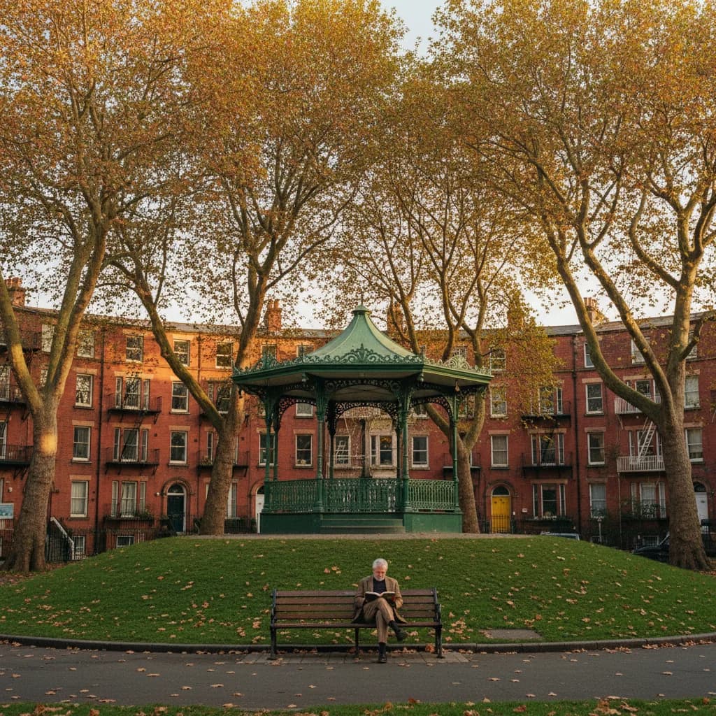
This is a residential estate, and the people on the benches are often neighbours who have lived here for decades, chatting or reading in the afternoon sun. Ask before including anyone recognisable, keep your voice down near entrances, and do not wander into private courtyards or stairwells. If a community event is running on the circus, enjoy it, but leave the close-up portraits of strangers to photographers who have built a relationship with the estate.
South to Christ Church and Fournier Street
From Arnold Circus, walk south across Bethnal Green Road and down Brick Lane, then turn right into Fournier Street. Its houses mainly date from the 1720s and many were occupied by Huguenot silk weavers who brought their skills from Lyon, Nantes and other French cities. Look for the wide attic windows that admitted light to the looms, the panelled doors with carved hoods, and the shutters that many owners still close each evening.
At the western end stands Christ Church Spitalfields, designed by Nicholas Hawksmoor and consecrated in 1729, its white stone spire towering over the brick street. The strongest composition is from the eastern end of Fournier Street, looking west so the spire closes the long line of doorcases. Late afternoon puts the sun behind the church and turns the spire into a silhouette, while overcast days give you even detail across every facade.
When to Go and What to Leave Out
A weekday morning keeps Redchurch Street and the estate calm, while Fournier Street looks good at almost any hour. Sunday is a different story: Columbia Road, a few minutes east of Arnold Circus, fills with its Sunday flower market, and Brick Lane becomes crowded. That suits street photographers who want energy, but it makes architectural frames harder. Choose the day according to the pictures you want, not the other way round.
One honest verdict: skip the queue for the most famous murals near Brick Lane if your time is limited. They are photographed by thousands of visitors every week, and they may be painted over before you share them. The Boundary Estate gables and the doorways of Fournier Street are permanent, under-photographed by comparison, and far more likely to give you a set of images that still feels fresh a year from now.
Practical Notes for the East London Loop
Shoreditch High Street station on the Overground is the natural start, and Liverpool Street is a short walk from the Spitalfields end. The route is free, almost flat and entirely on public streets or the open gardens of Arnold Circus. Bring a light jacket, since the estate's tall blocks create wind tunnels on cold days, and keep a zoom or 50mm prime handy for the chimney and gable details high above.
If you want help sequencing the walk around a Sunday market or a weekday lunch break, ask Karpo in the Karpo APP to put these stops in an order that fits your time and starting station. Karpo can suggest the route and calmer side streets to add when Brick Lane feels packed, while the composition, the patience and the conversations with neighbours along the way remain the heart of the walk.
Ask Karpo for more information.
Keep reading
- Bloomsbury Mews Walk Planner: Literary Brick Passages
 Belgravia Mews Walk Planner: Stucco Arches and Alleys
 Notting Hill Mews Walk Planner: Quiet Painted Lanes