The Shore Parkway Beach Below the Verrazzano That Nobody Calls a Beach
Where the Map Gives Up
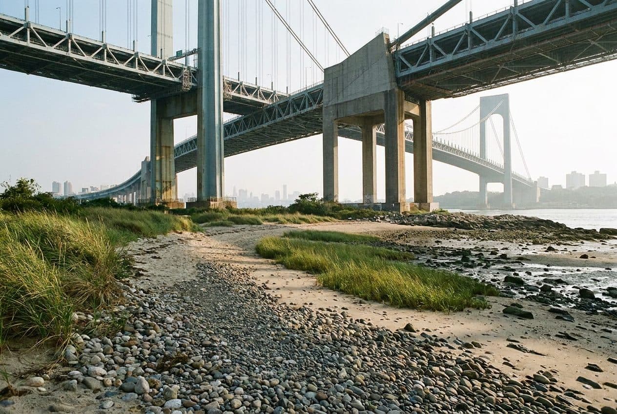
There exists a peculiar category of urban space that falls between jurisdictions, between intentions, between the lines that city planners draw on their carefully gridded maps. The strip of shoreline beneath the Verrazzano-Narrows Bridge's Brooklyn approach belongs firmly to this category. It is not a beach in any official sense. The Parks Department does not maintain it. The Department of Transportation does not acknowledge it. The Army Corps of Engineers, whose domain technically extends to mean high water, has apparently never given it a second thought.
And yet, for residents of Bay Ridge who have lived in the neighbourhood long enough to remember when the bridge was still being built, this half-mile of harbour shore has always been exactly what it appears to be: a beach. They have walked their dogs here for decades. They have brought their children to skip stones across the upper bay. They have sat on the sand and pebble mix as the afternoon light turned the bridge's suspension cables into threads of hammered gold.
The beach exists in an administrative gap—too close to the bridge for formal recreation designation, too far from Fort Hamilton's military boundaries for anyone in uniform to care. This bureaucratic no-man's-land has, paradoxically, preserved something increasingly rare in New York City: a piece of waterfront that belongs to no one and therefore, in the way that truly matters, belongs to everyone who knows where to find it.
Through the Gap in the Guardrail
Access to the beach requires a small act of urban intuition. Shore Parkway, that ribbon of greenway that traces the Belt Parkway's edge through southern Brooklyn, runs directly above the shoreline here. Joggers pass. Cyclists pedal toward Coney Island. Dog walkers pause to let their charges investigate particularly interesting patches of grass. Most of them never look down.
But there is a gap in the guardrail—unremarkable, unannounced, appearing on no official map—where the concrete gives way to a worn footpath descending toward the water. Local Bay Ridge residents have been using this passage for decades, their feet gradually compacting the soil into something resembling a trail. The gap has never been formalized, never been improved, never been acknowledged by any city agency. It simply persists, the way neighbourhood shortcuts always do, maintained by use rather than intention.
The descent takes perhaps thirty seconds. The sound of traffic fades with surprising speed, replaced by the lap of harbour water against the shore and the deeper hum of the bridge overhead. The transformation is complete enough to feel almost theatrical, as if the city has provided a trapdoor for those who know where to step.
A Century of Harbour Glass
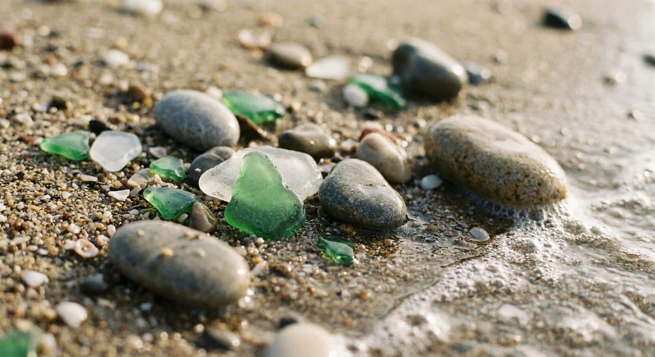
The beach itself defies easy categorization. It is not the fine white sand of Caribbean fantasy, nor the coarse brown grit of typical urban shoreline. Instead, the surface presents a geological record of New York's maritime past: sand mixed with pebbles, shells worn smooth by tidal action, and—most remarkably—compressed sea glass in colours that have largely vanished from modern production.
The glass here has been tumbling in the harbour for generations, smoothed by decades of salt water and sediment until no edge remains sharp enough to cut. Most of it comes in the expected palette of clear, brown, and the pale green of modern beer bottles. But scattered among these common specimens are pieces of a particular opaque green that collectors recognize immediately: Duraglass, the proprietary formulation that dominated beer bottle production in the 1940s and 1950s. These fragments have been in the water long enough to acquire a frosted patina that makes them glow in afternoon light.
Beachcombers who know what they're looking for can spend hours here, sifting through the shoreline's offerings. The glass tells a story of harbour traffic, of ships provisioned with cases of beer, of bottles discarded overboard or washed from long-demolished waterfront bars. Each piece has traveled its own path to this particular stretch of shore, carried by currents that have been circulating through the Narrows for centuries.
The Golden Hour Beneath the Span
Photographers discovered this beach years ago, though they guard the location with the protective silence common to those who have found something worth keeping. The attraction is not the beach itself but what happens above it when the afternoon light reaches a particular angle.
Because the shore faces northwest across the upper harbour, it catches the sun as it descends toward New Jersey. From around four o'clock onward, depending on the season, that light strikes the Verrazzano's suspension cables at an angle that transforms them. The steel, normally a utilitarian grey, takes on the colour of old gold. The cables seem to glow against the deepening blue of the sky, each strand distinct, the entire array suggesting the strings of some impossible instrument.
The bridge's underside, visible from this vantage point in a way it never is from the roadway above, reveals details that drivers crossing to Staten Island will never see: the massive concrete approach span, the intricate lattice of support structures, the way the entire assembly seems to hover rather than stand. Photographers set up tripods on the sand and wait for the light to reach its peak, capturing images that make the familiar bridge look almost alien in its beauty.
The View Across the Water
Beyond the bridge, Staten Island presents itself as a surprisingly green presence on the harbour's far shore. The island's North Shore communities—St. George, Tompkinsville, Stapleton—are visible as clusters of buildings rising from the waterline, close enough to seem almost reachable, far enough to maintain their mystery.
The harbour traffic provides constant entertainment for those willing to sit and watch. Container ships heading for the port facilities at Howland Hook pass through the Narrows with the slow inevitability of weather systems, their decks stacked with shipping containers in faded primary colours. Tugboats escort tankers toward the Kill Van Kull. The Staten Island Ferry, bright orange against the grey-blue water, makes its endless circuit between St. George and Whitehall.
On clear days, the Statue of Liberty is visible to the north, a small green figure on her island pedestal. The Manhattan skyline rises behind her, impossibly distant from this vantage point, a reminder that New York City contains multitudes—that the same metropolis holds both the glass towers of Midtown and this forgotten strip of harbour shore where the only sounds are water and wind and the occasional cry of a gull.
The Regulars
The beach has its community, though community may be too formal a word for the loose collection of individuals who find their way here. There are the dog walkers, mostly retirees from the surrounding blocks, who appreciate a stretch of shoreline where their animals can run without leashes or judgement. There are the fishermen who cast lines into the harbour at dawn, seeking striped bass and bluefish with the patient optimism of their kind.
There are the teenagers from nearby schools who come here to escape the surveillance of parents and teachers, sitting on driftwood logs and talking about whatever teenagers talk about when they think no one is listening. There are the solitary figures who simply want to sit by the water and think, or not think, or watch the light change on the bridge cables as the afternoon wanes.
None of them call it a beach, exactly. They say "down by the water" or "under the bridge" or simply "the shore." The lack of an official name suits a place that exists outside official recognition. It is what it is, nothing more and nothing less: a half-mile of harbour shoreline where the city forgot to put up a fence.
Practical Notes
The beach lies beneath the Verrazzano-Narrows Bridge's Brooklyn approach, accessible via Shore Parkway between Bay Ridge Avenue and the 69th Street Pier. Look for the gap in the guardrail where an informal footpath descends to the shore—it's approximately halfway between the two landmarks. The R train to Bay Ridge Avenue places visitors within a fifteen-minute walk. Wear shoes suitable for uneven terrain; the path down can be slippery after rain. The beach is not maintained, so visitors should bring what they need and carry out what they bring. For the best light on the bridge cables, arrive by 3:30 PM in summer, earlier in winter months. The area is technically public land, though its status remains ambiguous—visitors have never been prohibited, but neither has access been formally sanctioned. Swimming is inadvisable due to harbour currents and water quality.
Tags: #BayRidge #VerrazzanoBridge #HiddenNYC #BrooklynBeaches #SeaGlass #NYCPhotography #ShoreRoadParkway #UrbanExploration #NewYorkHarbor #GoldenHour #SecretNYC #BrooklynWaterfront #NYCHiddenGems #BeltParkway #StatenIslandView
Sources consulted: timeout.com · nymag.com · thrillist.com · eater.com
All trademarks are the property of their respective owners.
Ask Karpo first
Want to know the best time to visit this shoreline, whether the tide is favourable, and how to access the path from the nearest subway? Ask Karpo for a live Bay Ridge shore update.