Most walking routes in Singapore are designed as walks. Joo Chiat Road to East Coast Park is not designed as a walk at all — it is a residential street that happens to end at a sea wall, and the forty-five minutes between the start and the finish are one of the clearest urban-archaeology readings available in the city, if you are willing to do it on foot rather than in a taxi.
The walk begins near the Joo Chiat Road / East Coast Road intersection, passes through one of Singapore's most intact pre-war shophouse grids, crosses a main arterial road, and ends at the sea. In the process you cross three distinct decades of Singaporean urban planning — 1920s Peranakan mercantile, 1970s reclamation-era modernism, 2010s lifestyle retrofit — in about two kilometres.
Why Joo Chiat looks the way it does
Joo Chiat Road is named after Chew Joo Chiat, a Teochew immigrant trader who by the late nineteenth century had become one of the largest private landowners in the Katong area — the "King of Katong," in period shorthand. He donated the road to the colonial authorities in exchange for it being named after him, which is how a residential street in post-independence Singapore still carries the name of a nineteenth-century Chinese plantation owner.
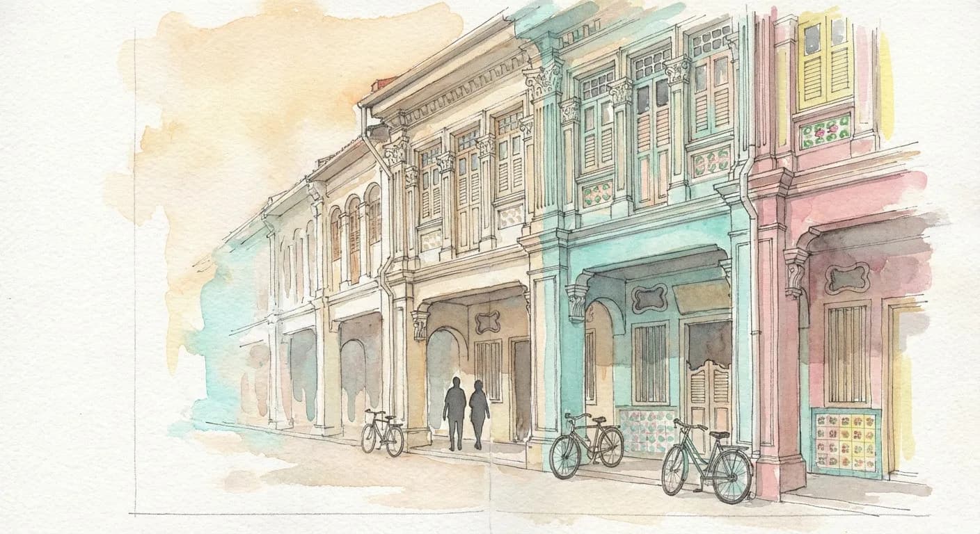
The shophouses along Joo Chiat and the adjacent Koon Seng Road were built mostly between the 1920s and 1930s, in what architectural historians call the Late shophouse style — a Singaporean hybrid that combines Chinese structural logic (five-foot way, narrow frontage, deep plan) with Western decorative vocabulary (Corinthian columns, plaster rosettes, pastel colour panels) and Peranakan polychrome tiles at ground level. The effect, at eye level, is architecture that looks like nothing else in Asia. The twin blocks on Koon Seng Road, with their near-symmetrical facades in turquoise, pink, and pale yellow, are the most-photographed shophouse stretch in the country.
In 1991, the Urban Redevelopment Authority gazetted 518 buildings in Joo Chiat for conservation. The area was declared a national heritage conservation zone in 1993, and in 2011 Joo Chiat became the first neighbourhood in Singapore formally designated as a Heritage Town. Which means the facades and rooflines of the 1920s–1930s shophouses cannot be altered — which is why walking here feels fundamentally different from the renovated entertainment precincts closer to the city centre.
The walk, in four stages
Stage 1 — Joo Chiat Road to Koon Seng Road (approx. 15 minutes, 700m)
Start anywhere along Joo Chiat Road between Everitt Road and Tembeling Road. The street itself is narrow and two-way, with the five-foot way providing a continuous sheltered walking line along both sides. Most of the ground-floor units here are still active — Peranakan food, tailors, a couple of indie cafés that arrived in the last decade, some older provision shops that have been there since before the conservation zoning. You are walking inside a living street, not a film-set approximation of one.
Turn left into Koon Seng Road for the two-block walk between Joo Chiat Road and Everitt Road. This is the postcard stretch: two facing rows of restored 1920s shophouses, painted in the original Peranakan palette, with the full decorative repertoire visible at eye level — ventilation tiles, carved timber doors, hand-painted tile panels set into the lower walls. Most travellers spend fifteen to twenty minutes here. Slow walkers spend longer. The details reward time.
Stage 2 — Koon Seng back to East Coast Road (approx. 10 minutes)
Return to Joo Chiat Road, turn south, and walk toward the sea. This stretch is the transition zone: the shophouses gradually give way to 1970s-era walk-up flats and a handful of newer mid-rise residential developments. The grid here starts loosening. Street trees widen, the pavements become less continuous, and you can feel, without being able to articulate exactly why, that you are leaving the colonial-era fabric and entering post-independence Singapore.
Cross East Coast Road at the traffic lights (there is no safe jaywalking option — the road carries fast traffic). On the other side, take the underpass or the overhead pedestrian bridge that leads into East Coast Park.
Stage 3 — East Coast Park entry to the sea wall (approx. 10 minutes)
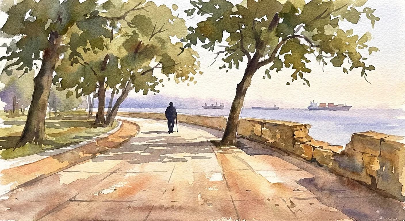
East Coast Park is built on reclaimed land — the coastline of Singapore in 1960 was significantly further inland than it is today, and the park sits on what was, sixty years ago, ocean. The transition from Joo Chiat's dense pre-war grid to the park's open mid-century modernist landscaping is the single sharpest architectural contrast in the walk. You exit a shophouse street and, within three minutes, you are on a wide asphalt coastal promenade lined with sea almond trees.
Stage 4 — Along the sea wall (as long as you want)
Turn left (east) and walk along the coastal path. The Marina Bay skyline is visible to the west in clear weather; directly south is the Singapore Strait, with container ships anchored at the horizon. The promenade continues for more than 15 kilometres if you want it to — most walkers turn back after 20 minutes. A number of hawker clusters and the East Coast Lagoon Food Village are within walking distance of the entry point for a post-walk meal.
The three decades, in one sentence
You cross the 1920s (the Peranakan shophouse grid), the 1970s (the walk-up transition block and the reclamation-era park), and the 2010s (the boutique cafés and restored tile work on Joo Chiat that only exist because the 2011 Heritage Town designation made restoration economically viable) — in under an hour, on foot, without a single guided commentary. The walk is the commentary.
Practical notes
- Best window: weekday mornings between 8:30 and 10:30 am, or late afternoon (4–6 pm) to catch the shophouse colours at the best angle and avoid the afternoon heat. Avoid Sundays mid-day — Koon Seng Road gets visibly crowded with photography groups.
- Total time: 45 minutes briskly, 90 minutes with photo stops and one coffee break, two hours if you stop for a full Peranakan meal.
- What to wear: this is tropical walking — 30°C, high humidity. Lightweight, breathable. Cap and water are mandatory. The five-foot way provides shade for most of Joo Chiat Road; the coastal promenade is partially shaded.
- Where to eat along the way: any Peranakan restaurant on Joo Chiat Road — ask for kueh pie tee and ayam buah keluak. At East Coast Park, the Lagoon Food Village is the classic post-walk option.
- Walking solo: Joo Chiat is one of the easier Singapore neighbourhoods for a solo walk — well-lit, continuously inhabited, dense residential traffic, active five-foot way that keeps sightlines clear. The route is straightforward with no isolated stretches. East Coast Park is well-patrolled, with frequent joggers and families, and the promenade is continuously occupied during daylight. Solo walking is common and unremarkable. Evening walks are generally safe in Joo Chiat but the East Coast Park promenade becomes dimmer after sunset — daylight completion is recommended for solo visits.
- Getting there: the nearest MRT station to the start is Paya Lebar (East-West / Circle line), roughly 15 minutes on foot or a short bus ride. The nearest station to East Coast Park is more of an issue — there is no MRT station at the sea. A Grab back from the park is the standard return.
- What to avoid: the Joo Chiat area has, historically, had a mixed reputation after dark (some sections of Joo Chiat Road further north have nightlife venues). None of this affects a daytime walk, but evening solo walks along the northern end of Joo Chiat Road are not recommended for visitors unfamiliar with the neighbourhood.

The point
The Joo Chiat-to-East-Coast walk is not the most efficient way to see Peranakan heritage (the Peranakan Museum is more efficient), and it is not the best way to see the sea (a taxi to East Coast Park is faster). What the walk offers is something neither of those shortcuts can: the experience of crossing three decades of Singaporean urban planning on foot, in sequence, with each decade's architectural logic visible in your periphery as you pass through it.
You start the walk inside a 1920s colonial-era trading street. You finish it on a promenade that did not exist before 1974. In between, you walk past a 2019 boutique Peranakan café in a restored 1925 shophouse, owned by the third generation of a family that has lived on the street since before the British left.
The walk is the argument. The sea is just where it ends.
Tags: #JooChiat #Katong #Singapore #Peranakan #Shophouses #EastCoastPark #KarpoFinds #TheLongWayHome #Vol4
Sources consulted: ura.gov.sg · roots.gov.sg · nparks.gov.sg · en.wikipedia.org · visitsingapore.com
All trademarks are the property of their respective owners.


