 Chinatown New in Town Weekend Planner: Errands and Temples
Weekend Plans
Kallang Scenic Waterfront Trail: 4km Sunset Basin Loop Route
Explore the 4km Kallang Basin scenic waterfront trail in Singapore for free. Enjoy open river skyline vistas and illuminated night walking paths.
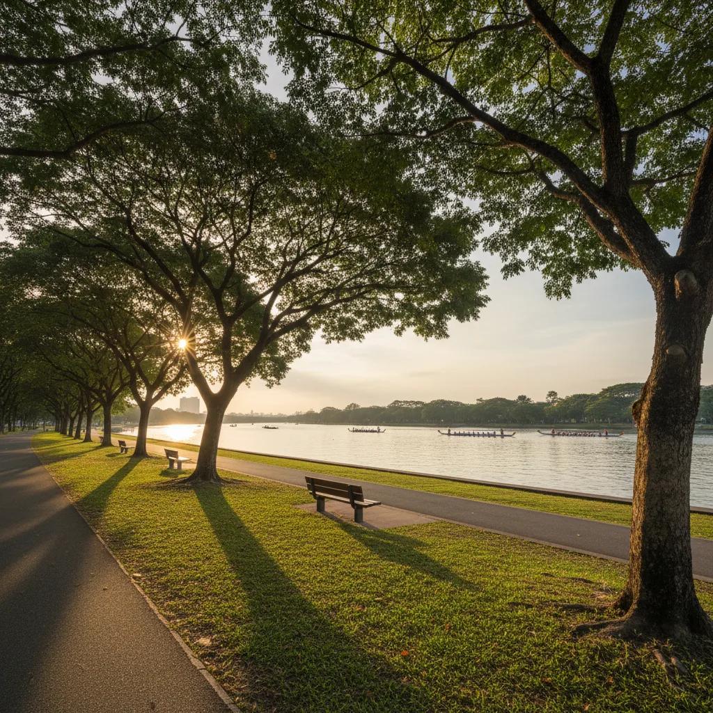
Following a scenic waterfront trail near me around Kallang Basin reveals an authentic, breezy side of Singapore that remains pleasantly unburdened by tourist crowds. Covering approximately four kilometers along flat, well-maintained shoreline pathways, this scenic loop connects the historic open lawns of Kallang Riverside Park with the sleek modern promenade fronting the Singapore Sports Hub. The route provides panoramic vistas across expansive reservoir waters where dragon boaters paddle under open skies, offering an invigorating outdoor circuit that costs absolutely nothing to explore. From tranquil river bends to architectural vantage points, the trail presents an effortless waterside escape within minutes of the city core.

Initiating the Loop at Stadium Riverside
Beginning your Kallang Basin walk from Stadium MRT station Exit A positions you immediately alongside the wide, rubberised-and-paved waterfront concourse outside the Singapore Sports Hub. Unlike the tightly enclosed commercial promenades of the city centre, the river banks here open up dramatically to an expansive tropical sky. From the water edge, competitive rowers and community dragon boat crews glide across the calm surface of the basin during late afternoons, creating a distinctive rhythmic cadence that accompanies the first kilometer of your walk. The trail faces directly west across the water, making it a prime orientation point for observing changing cloud formations and golden hour hues before sunset. The pathway here easily accommodates cycling and walking without conflict, marked by clear directional painted lines.
Tanjong Rhu Promenade Bridge Crossing
Navigating northward brings you across the graceful pedestrian footbridge spanning the mouth of the Geylang River into the Tanjong Rhu Promenade. This tree-canopied corridor provides continuous shade under mature angsana and sea apple trees, with shaded stone resting benches situated beneath the trees for unhurried pauses. Residential condominiums stand well back from the shoreline, preserving public access along a continuous brick-paved boardwalk that remains open to all visitors. The water remains undisturbed by commercial boat traffic here, attracting native kingfishers, grey herons, and smooth-coated otters that occasionally hunt fish along the rocky shoreline revetments. It feels secluded, quiet, and separated from the surrounding highway network.
Kallang Riverside Park North and Green Flats
Crossing the tranquil northern bend leads walkers directly into Kallang Riverside Park North along Kampong Bugis. Spanning both banks of the Kallang River, this historic public parkland preserves wide grassy meadows that feel refreshingly open and unpretentious. Runners share the broad asphalt trail with families teaching children to bicycle along dedicated lanes clearly demarcated from pedestrian walkways. Mature rain trees line the inland edge, casting wide cooling shadows that mitigate daytime heat even during warmer afternoons. Stopping near the mouth of the Rochor River offers a serene vantage point looking back toward the dome of the National Stadium across the glassy water. You can rest on the grassy slopes while watching sea breezes ripple across the surface.
Merdeka Bridge Historic River Crossing
Completing the loop requires transitioning across the pedestrian walkway of Merdeka Bridge, the landmark 1956 road bridge spanning the Kallang River. The elevated sidewalk is securely separated from vehicular traffic by substantial concrete balustrades. Constructed as part of Singapore's post-war infrastructure and officially opened in August 1956, the crossing originally featured the famous Merdeka Lions sculptures at its approaches before they were relocated to protect the heritage artifacts. The walkway offers an expansive panoramic perspective over both the inner basin and the outer waterways leading south toward Marina Reservoir. Looking south from the bridge deck reveals the distant silhouettes of Marina Bay Sands and the Singapore Flyer, providing a compelling contrast between historic mid-century civil engineering and contemporary high-rise architecture. The wide pedestrian lane ensures you never feel rushed by bicycle commuters crossing between districts.
Stadium Waterfront and Waterfront Steps
Descending the southern ramp returns the trail to the Singapore Sports Hub precinct, where wide tiered concrete steps slope gently down toward the water. On weekday evenings between 6:00 PM and 7:30 PM, community runners, kayakers, and local residents gather here to stretch and watch the water turn indigo as twilight sets in. The path along this southern flank is exceptionally broad and uncluttered, which prevents any sensation of crowding even when local school canoe clubs are moving their equipment along the slipways. The reflective glass facade of the stadium catches the evening glow, creating an impressive urban backdrop to conclude the four-kilometer loop.
Timing and Climate Navigation Around the Basin
Because large sections of the Kallang Basin trail traverse open parkland with minimal overhead canopy, scheduling your visit around the tropical sun is critical. Walking between 10:00 AM and 4:00 PM will expose you to intense solar glare radiating off the open water. The ideal window starts after 5:30 PM, allowing you to catch the sunset glow behind the city skyline while walking in cooling river breezes. Early morning walkers who arrive between 6:30 AM and 8:00 AM will experience calm water, active birdlife, and temperatures hovering comfortably around 25 degrees Celsius. If cloud cover rolls in, the entire circuit remains pleasantly breezy and comfortable.
Visitor Facilities and Wayfinding Logistics
The entire 4-kilometer Kallang Basin loop is open to the public twenty-four hours daily with zero entry tickets or registration gates. Multiple MRT stations provide flexible access points along the perimeter: Stadium station on the Circle Line serves the southern shore, while Kallang station on the East West Line sits a brief five-minute walk from the northern park entrance. Clean public restroom pavilions and filtered water drinking stations are located inside Kallang Riverside Park and within the retail concourses of Kallang Wave Mall adjacent to the stadium. Adequate public rubbish bins and lighting poles line the path, ensuring a safe, hygienic walking environment.
Planning Your Basin Walk with Karpo APP
Opening Karpo APP makes it straightforward to save this 4-kilometer Kallang Basin scenic waterfront trail to your personal recreation plan before heading out. The saved route card outlines the walking progression from Stadium Riverside past Tanjong Rhu Promenade and Merdeka Bridge, alongside practical arrival options via Stadium and Kallang MRT stations. If afternoon clouds threaten rain, the card notes covered stadium arcades and waterfront shelters along the perimeter so you can adjust your timing accordingly. It functions as a convenient static planning overview for discovering Singapore's breezy river scenery at your own unhurried pace.
Ask Karpo for more information.
Keep reading
- Chinatown New in Town Weekend Planner: Errands and Temples
 Kampong Glam New in Town Weekend Planner: Mosque to Murtabak
 Holland Village New in Town Weekend Planner: Meet People