 Marina Bay Food Market Grazing Route After a Conference Day
Neighborhood Guides
Kallang River Scenic Canal Bridge Route Promenade Loop
Discover the Kallang River scenic canal bridge route in Singapore along historic river crossings, suspension footbridges, and expansive waterfront basin trails.
Framed by broad tidal horizons and dynamic sporting infrastructure, the Kallang River scenic bridge circuit provides Singapore's most expansive canalized waterfront walk. As Singapore's longest natural river, the Kallang flows ten kilometers from Lower Peirce Reservoir through central heartlands before opening into the sweeping Kallang Basin. Tracing the lower reaches of this waterway reveals a compelling contrast between early twentieth-century industrial infrastructure and world-class modern suspension footbridges. Walkers looping across the river enjoy sweeping panoramic vistas across open water, refreshing marine winds, and an inspiring sense of Singapore's rich water history.

Sir Arthur's Bridge anchors the northern threshold of this crossing loop, carrying Kallang Bahru across the canalized river corridor near Geylang and Bendemeer. Constructed in nineteen twenty-seven and named in honor of Sir Arthur Henderson Young, the longest-serving Governor of the Straits Settlements, this historic concrete road bridge represents an important milestone in Singapore's pre-war road network. Walking across its broad pedestrian sidewalk offers clear views down the straight canal corridor toward the newly naturalized riparian wetlands of the Kolam Ayer ABC Waters promenade.
Historical plaques mounted near the bridge abutments trace how the surrounding marshes were reclaimed and engineered into vital drainage canals during the early twentieth century. From this vantage point, walkers can observe the steady transition of the canal as it widens toward the lower basin, flanked by green park connector paths that invite continuous downstream exploration. The solid concrete balustrades and sturdy piers stand as tangible testaments to pre-war civil engineering that continue to serve the daily community.
Pacing Across Tanjong Rhu Suspension Bridge
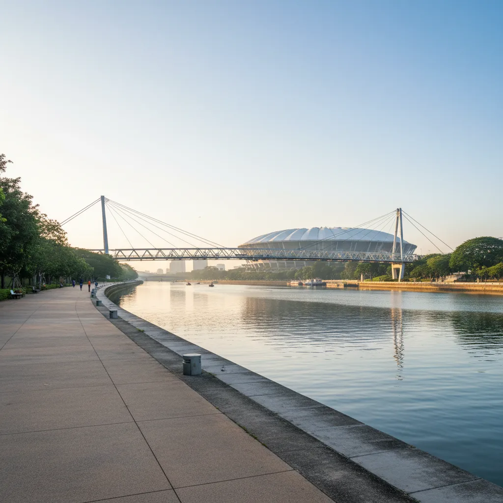
Heading south toward the tidal basin, the Tanjong Rhu Suspension Footbridge commands attention as one of the most picturesque pedestrian crossings in Singapore. Featuring a slender curved steel deck suspended from soaring white A-frame pylons and heavy catenary cables, the bridge spans one hundred and thirty meters across the mouth of the Geylang River into the Kallang Basin. Stepping onto the suspended deck produces a subtle, satisfying spring that reminds pedestrians of the delicate tension engineering keeping the bridge aloft.
Crossing the Tanjong Rhu footbridge connects the quiet residential waterfront apartments of Tanjong Rhu directly with the buzzing concourses of the Singapore Sports Hub and the National Stadium. Stopping at mid-span delivers an unobstructed three-hundred-and-sixty-degree panorama taking in the massive dome of the stadium, the distant skyline of Marina Bay, and dragon boat crews slicing through the calm morning waters below. The wide timber-planked deck offers ample space to pause, lean against the smooth nautical railings, and watch sea eagles circle high on thermal currents.
Merdeka Bridge stands further downstream as an enduring monument of mid-twentieth-century national pride, having opened in nineteen fifty-six along Nicoll Highway to bridge the mouth of the Kallang Basin. Spanning over six hundred meters with twenty-two pre-stressed concrete spans, the bridge was originally flanked by two monumental stone lions that now guard the Esplanade parkland. Walking along the pedestrian path beside Merdeka Bridge offers breezy vantage points across the open basin where kayakers and windsurfers train under the tropical sun.
Promenade Quality and Trail Safety Guidelines
Wide, well-graded asphalt paths and textured non-slip pavers line the entire Kallang River promenade, ensuring durable and secure footing in all weather conditions. The trail is fully separated from vehicular roadways through landscaped earth berms, flowering hedges, and dedicated grade-separated underpasses beneath busy arterial bridges like Nicoll Highway and Mountbatten Road. Tactile warning pavers mark the entry points to bridge ramps, providing seamless accessibility for runners, casual strollers, and wheelchair users alike.
Safety etiquette along this dynamic multi-use corridor centers on shared awareness between fast-moving sports cyclists, fitness runners, and family walking groups. Pavement arrows and clear speed limit indicators encourage wheeled path users to maintain moderate speeds and pass only on the right. Shaded hydration stations with multi-tiered water fountains, emergency call points, and automated external defibrillators are strategically placed at regular intervals near sports hubs and community plazas along both riverbanks.
Elevated viewing decks extend over the water at regular intervals along the Tanjong Rhu and Stadium promenades, providing designated resting zones where sightseers can stop without blocking pedestrian traffic lanes. Durable marine-grade stainless steel railings line the water edge, while energy-efficient LED lighting columns ensure clear visibility and personal security along the entire five-kilometer water loop.
Changing Light and Atmospheric Basin Reflections
Morning light across the Kallang Basin offers a visual spectacle of energetic outdoor life and serene water reflections. Between six-thirty and eight in the morning, the glassy surface of the basin mirrors the rising pink sun and the silver dome of the National Stadium. Rowing sculls, competitive dragon boat teams, and stand-up paddleboarders glide across the water in coordinated rhythm, their oars creating rhythmic ripples that sparkle in the soft dawn light.
Sunset brings a cool maritime breeze as the setting sun casts a dramatic golden veil across the wide waterway. The evening illumination of Tanjong Rhu Suspension Bridge turns the white pylons into glowing navigational beacons against the darkening sky, while the programmable LED roof of the National Stadium shifts through brilliant displays of color. Walking the river loop at night offers an invigorating experience of cool waterfront air, expansive horizons, and sparkling city reflections stretching into the distance.
Strolling along the eastern shoreline under the open tropical night sky reveals a panoramic skyline illuminated by glowing city lights mirrored across the dark lagoon. The steady sea breeze carries a clean, salty fragrance that invigorates tired walkers, while the quiet lap of gentle basin waves against the stone seawall provides a soothing soundtrack for a late evening promenade.
Connecting Transit Hubs and Karpo APP Planning
Arriving at the Kallang River bridge circuit is remarkably straightforward through multiple conveniently situated MRT stations. Stadium MRT Station on the Circle Line sits right at the southern threshold of the Tanjong Rhu footbridge, making it an ideal entry point for exploring the basin. Kallang MRT Station on the East-West Line provides direct northern access to Sir Arthur's Bridge and the upper river park connectors, while Mountbatten MRT Station serves the eastern approach.
Checking the Karpo APP gives walkers immediate access to live tidal flow data, optimal loop itineraries, and weather radar updates to plan an enjoyable waterside journey. The application pinpoints tranquil observation decks, identifies water refill stations, and suggests connecting routes along the Pelton Canal toward Geylang Serai. Whether you are tracing historic pre-war bridges or enjoying a scenic sunset jog across the suspension span, the Kallang River route provides an unforgettable Singapore waterfront journey.
Ask Karpo for more information.
Keep reading
- Marina Bay Food Market Grazing Route After a Conference Day
 River Valley Food Market Grazing Route With Young Kids
 Serangoon Food Market Grazing Route for a Homecoming Weekend