 Marina Bay Food Market Grazing Route After a Conference Day
Neighborhood Guides
Kallang Basin Scenic Riverside Promenade Loop in Singapore
Circle Singapore's scenic Kallang Basin riverside promenade loop past the National Stadium, Tanjong Rhu footbridge, and open tidal waterways.
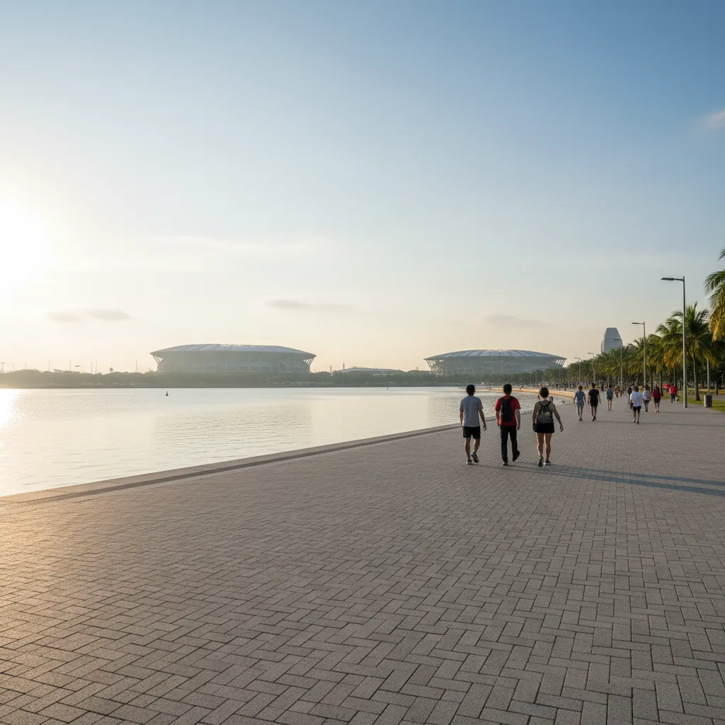
Circling the expansive tidal waters where the Kallang, Geylang, and Rochor rivers converge, the Kallang Basin waterfront riverside promenade loop is one of Singapore's premier waterside recreational corridors. Spanning a generous four-kilometer circuit around the historic sports precinct, this promenade offers unhindered panoramic views across open water toward the futuristic dome of the Singapore National Stadium and the downtown skyline beyond. Walkers and runners enjoy broad, barrier-free pathways that breeze alongside naturalized mangroves, modern sports architecture, and historic waterways.

Beginning the Circuit Along Stadium Riverside Walk
Setting out from the Stadium Riverside Walk right outside the Singapore Sports Hub, pedestrians are greeted by an expansive paved concourse that stretches over eight meters wide. The trail here runs parallel to the Kallang River mouth, edged by durable nautical railings and neatly trimmed green verges planted with sea hibiscus and fragrant pandan bushes. The spacious design easily accommodates casual walkers, brisk fitness enthusiasts, and family groups without any sense of crowding.
Modern stadium architecture looms dramatically above the inland side of the promenade, its colossal free-spanning domed roof providing an impressive structural backdrop against the tropical sky. The waterfront path remains refreshingly open to the prevailing coastal breezes that sweep inland from the nearby Marina Channel. Benches fashioned from weather-resistant composite timber are positioned facing the water every hundred meters, providing panoramic rest spots overlooking the broad aquatic expanse.
Coastal sea breezes keep the temperature along the basin significantly cooler than inland city streets, creating an invigorating microclimate for outdoor exercise. The walkway surface is constructed of high-traction asphalt and smooth granite paving, providing dependable grip even immediately following a passing morning rain shower. Interpretive signs along the river edge describe the rich maritime history of Kallang Basin, which served as Singapore's original boat-building center in the nineteenth century.
Spanning the Water via Tanjong Rhu Suspension Bridge
Approaching Tanjong Rhu Promenade along the southern arc of the basin, the path transitions onto the iconic Tanjong Rhu Suspension Footbridge. This slender, white-cabled pedestrian suspension bridge spans the mouth of the Geylang River, connecting the sports precinct directly to the tranquil residential neighborhood of Tanjong Rhu. Walking across the suspended timber deck offers a gentle, natural bounce and an unobstructed vantage point looking straight down the open waterway toward the Marina Bay skyline.
Suspended gracefully above the tidal currents, the bridge features wide viewing alcoves at mid-span where pedestrians can lean safely against the steel mesh railings to watch dragon boat teams and racing sculls slice through the calm water. The rhythm of team coxswains calling strokes echoes across the basin, providing an energetic athletic soundtrack to the morning walk. The open water surface reflects the clouds and stadium architecture like a vast marine mirror.
Glancing southward from the bridge, the lush greenery of Tanjong Rhu promenade welcomes walkers onto a peaceful, tree-lined waterfront trail. Towering casuarina and raintree specimens provide a dense green canopy that filters midday glare and showers the paved pathway with cool dappled shade. The path here hugs the edge of quiet condominium wharves, where private resident gardens overflow with tropical ferns and scarlet heliconias that spill over decorative perimeter walls.
Looping Through Kallang Riverside Park and Waterways
Descending onto the northern shoreline toward Kallang Riverside Park, the loop enters a more naturalistic riparian sanctuary. Here, the riverbanks have been thoughtfully restored with natural rock revetments and thriving mangrove clusters where mangrove crabs and mudskippers scurry across tidal mudflats during low water. Birdwatchers frequently gather along this reach with binoculars to observe resident collared kingfishers, striking grey herons, and migratory sandpipers foraging along the shoreline.
Shaded parkland pathways wind gently through groves of mature coastal trees, offering multiple dirt footpaths and paved options that meander past open recreational lawns and picnic gazebos. The Kallang Riverside Park section provides clean municipal restrooms, outdoor showers, and automated cold water dispensers designed specifically for long-distance trail users. The atmosphere here is serene, punctuated only by the rustle of coastal breeze through casuarina needles.
Dragon boaters and kayakers launch their colorful vessels from the nearby Singapore Water Sports Centre, adding vibrant maritime activity to the basin waters throughout the morning and late afternoon. Watching synchronized paddle strokes leave white trails across the blue water creates a uniquely captivating waterside experience. The path remains completely flat and accessible throughout, allowing strollers to maintain an easy, rhythmic walking pace.
Maritime Scenery, Water Sports, and Skyline Backdrops
Heading across the Merbusier pedestrian bridge over the Rochor River connection, walkers complete the northern loop and curve back toward the National Stadium concourse. This connecting bridge offers wide ramps on either bank, ensuring effortless navigation without having to climb steep steps. The final stretch along the Stadium Walk concourse opens up wide perspectives of the entire Kallang Basin loop, allowing walkers to trace the scenic route they have just traversed.
Wide unobstructed pathways ensure that walkers of all abilities can complete the circuit safely and comfortably. Dedicated tactile paving guides visually impaired users along the primary path spine, while low-glare solar lighting guarantees excellent visibility for those who prefer evening strolls under the starlit Singapore sky. The entire route is monitored and maintained to high municipal park standards.
Running along flat terrain with zero vehicular interference, this complete four-kilometer loop takes approximately fifty to sixty-five minutes to walk at a relaxed, steady pace. Fitness enthusiasts frequently combine the circuit with the adjoining 100PLUS Promenade—an elevated covered running track encircling the National Stadium—to add sheltered mileage during wet weather.
Surface Conditions, Resting Facilities, and Navigation Guide
Cooler morning hours from 6:30 AM to 9:00 AM provide the most rewarding conditions, when gentle sunrise light bathes the stadium dome in soft silver and water sports teams are most active on the basin. Late afternoons from 5:30 PM until sunset also offer pleasant maritime breezes and dramatic twilight reflections as the Singapore Flyer and downtown skyscrapers begin to illuminate across the western horizon.
Well-maintained hydration stations and spotless public restrooms are situated at the Singapore Sports Hub, the Water Sports Centre, and inside Kallang Riverside Park. Transport accessibility is outstanding: Stadium MRT Station on the Circle Line exits directly onto the Stadium Riverside Walk at the start of the loop, while Kallang MRT Station on the East-West Line sits a short seven-minute walk from the northern park boundary.
Ask Karpo for more information.
Keep reading
- Marina Bay Food Market Grazing Route After a Conference Day
 River Valley Food Market Grazing Route With Young Kids
 Serangoon Food Market Grazing Route for a Homecoming Weekend