 Chinatown New in Town Weekend Planner: Errands and Temples
Weekend Plans

Bukit Timah Historic Canal Towpath Walk? Trace Valley Water
Bukit Timah Canal offers a continuous pedestrian corridor following nineteenth-century valley drainage works past landmark rail bridges and greenery.
The Bukit Timah Canal, one of Singapore's most venerable drainage arteries, offers a unique opportunity to trace the island's water engineering heritage on foot. While Singapore's colonial waterways primarily served as arterial drainage, and timber transport canals rather than horse-drawn towpaths, modern paved pedestrian promenades now flank these historic banks. This guide invites you to explore the valley’s continuous evolution, from a marshy agricultural plain in the 1830s to a vital storm water management channel today. The route provides a contemplative journey along a waterway integral to Singapore's development and urban fabric.
Tracing Ancient Waterways: From Marshes to Modernity
The Bukit Timah Canal's origins trace back to the 1830s, when early colonial efforts began to drain the extensive marshy agricultural valley between Bukit Timah Hill and Rochor. This initial excavation facilitated cultivation and reduced mosquito-borne illnesses, laying the groundwork for future urban expansion. The canal paralleled historic plantation roads, which later became significant thoroughfares, and its development was intrinsically linked to the region's agricultural productivity and settlement patterns. Understanding this early phase reveals the profound impact of water management on Singapore's historical landscape.
Over nearly two centuries, the canal has undergone repeated deepening and widening projects, adapting to the island's escalating storm water management needs. Its current iteration is a testament to continuous hydrological engineering and forward-thinking urban planning. Modern park connectors and dedicated pedestrian sidewalks now follow its historical banks, offering walkers a serene and accessible route. The waterway's transformation from a simple ditch to a sophisticated urban drain reflects Singapore's relentless pursuit of resilience and sustainability in its infrastructure. These pathways provide a direct connection to the canal's enduring legacy.
Walking along the Bukit Timah Canal today, one observes a harmonious blend of historical infrastructure and contemporary green spaces. The tranquil verges of King Albert Park provide lush surroundings, offering respite from the urban hustle. Pedestrians can appreciate the scale of engineering works while enjoying the natural beauty of the park connector network. Notice the intricate details of the canal's revetments and the subtle changes in its width and depth along different sections. The walk is an opportunity for quiet reflection on the interplay between natural landscapes and human ingenuity, inviting a deeper appreciation for Singapore’s environmental efforts.
Engineering Marvels: Bridges and Canal Crossings
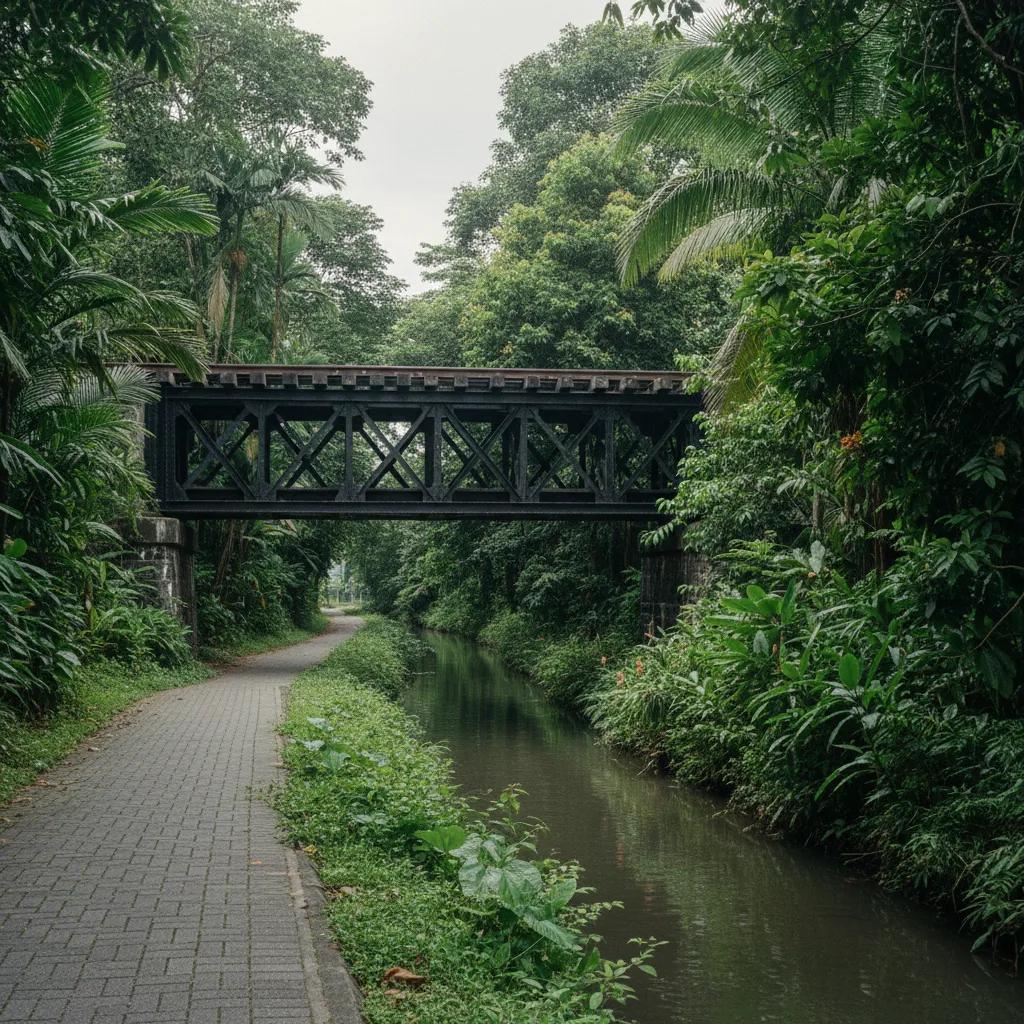
A highlight of the Bukit Timah Canal walk is the historic Railway Corridor iron truss bridge, a significant architectural and engineering landmark. This bridge, once part of the Singapore-Kranji railway, stands as a tangible link to Singapore's early transportation network. Its robust ironwork and design speak to the industrial capabilities of its era, representing a crucial piece of the island's infrastructure heritage. The structure offers a compelling visual narrative of the past, marking where the railway once traversed the valley and the canal. Observing its intricate construction provides insight into historical bridge building techniques and their endurance.
The canal's route is punctuated by numerous crossings, including those at Sixth Avenue, which illustrate the continuous integration of the waterway into the urban fabric. These crossings are vital for maintaining connectivity within the residential and commercial areas adjacent to the canal. Historically, these points were critical for agricultural access and trade, facilitating movement across the valley. Modern bridges provide safe and accessible passages for pedestrians and vehicles, ensuring that the canal remains an integrated part of daily life. Each crossing tells a story of evolving urban design and logistical considerations.
As you proceed, the waterside scenery shifts, revealing diverse perspectives of the canal and its surroundings. The paved paths ensure a smooth and accessible walking experience, allowing for a comfortable pace. Observe the subtle changes in the canal's banks, from naturalistic slopes to engineered concrete structures, reflecting different periods of development. The pedestrian flow is generally unhindered, providing ample space for contemplation and enjoyment of the green corridor. This journey offers a visual timeline of urban development alongside the sustained commitment to green infrastructure and public accessibility.
Nature's Canopy: Rain Trees and Green Corridors
The Bukit Timah Canal is often shaded by a magnificent rain tree canopy, particularly in certain sections, providing natural coolness and a sense of tranquility. These mature trees not only enhance the aesthetic appeal of the canal banks but also contribute to the ecological health of the corridor. The broad, spreading canopies create a picturesque setting, inviting walkers to linger and enjoy the natural environment. The path surfaces are well-maintained, predominantly paved, and suitable for all ages and fitness levels. The green surroundings create a natural buffer, insulating the walk from the nearby urban thoroughfares.
Modern urban planning in Singapore has strategically preserved and enhanced these green corridors, ensuring that historical waterways like the Bukit Timah Canal retain their ecological value and public amenity. The integration of park connectors along the canal demonstrates a commitment to sustainable urban living and the preservation of natural heritage. This design philosophy transforms functional drainage infrastructure into vibrant recreational spaces. It showcases how innovative planning can bridge the gap between historical land use and contemporary environmental needs. The result is a resilient and appealing urban landscape.
Choosing different sections of the canal walk can offer varied experiences, from densely canopied stretches to more open, expansive views. The section near King Albert Park is particularly scenic, with wide verges and mature trees ideal for photography and quiet reflection. Consider starting your walk at a point that maximizes exposure to the historical railway bridge for its architectural significance. Photo viewpoints are abundant, capturing the interplay of water, greenery, and historical structures. Plan your route to explore the diverse characteristics of this enduring waterway and its surrounding environment.
Historical Pathways: From Utility to Recreation
While Singapore's canals were primarily engineered for drainage and agricultural support, not for traditional horse-drawn towpath navigation, their modern transformation into pedestrian promenades offers a comparable recreational experience. The contemporary walking paths provide dedicated bankside access, allowing explorers to trace the historical course of the waterway. This evolution from a purely utilitarian function to a combined recreational and ecological asset reflects a broader shift in urban planning philosophy. The ability to walk along these waters allows for an intimate engagement with Singapore's developmental narrative, appreciating its engineering feats and greening efforts.
Key landmarks along the Bukit Timah Canal not only serve as navigational markers but also tell deeper stories of the island's progress. The historic Railway Corridor iron truss bridge is a powerful symbol of early transportation infrastructure, connecting generations through its sturdy design. The verdant expanses of King Albert Park and the periodic canal crossings at Sixth Avenue highlight the ongoing integration of the waterway into residential and commercial life. These structures are more than mere functional elements; they are enduring monuments to Singapore’s strategic development. Each landmark contributes to the rich tapestry of the canal's history.
The editorial illustrations accompanying this article are AI-generated, designed to visually enhance the narrative and convey the atmosphere of the Bukit Timah Canal walk. These images serve to complement the descriptive text, providing a visual representation of the historical landmarks, lush canopies, and serene waterside paths. They aim to immerse the reader in the experience, illustrating the beauty and historical significance of the route. The visuals offer an artistic interpretation of the canal's enduring legacy, inviting readers to envision their own journey along this historic watercourse. They support the article's authoritative and detailed presentation.
Practical Notes: Plan Your Route Along the Water
Walking the Bukit Timah Canal is a refreshing way to experience Singapore's urban landscape and historical engineering. The paths are generally paved and flat, suitable for all ages and mobility levels, and are well-maintained by the National Parks Board. Wear comfortable walking shoes, and consider bringing water, especially during warmer periods. Public path etiquette includes keeping to the left, sharing space with cyclists, and disposing of litter responsibly in designated bins. While the canal is open 24/7 for walking, daytime offers the best visibility and appreciation of the scenery and landmarks. Access points are plentiful, often near public transport hubs, making it easy to join and leave the route at various points. There are no commercial shops or specific dining recommendations directly along the canal path, encouraging a focus on the natural and historical environment. In the Karpo APP, ask for a waterside walking route in Singapore focusing on Bukit Timah Canal history and your preferred walking distance. Surveying this valley alignment allows you to examine two centuries of flood mitigation alongside surviving colonial railway heritage.
Ask Karpo for more information.
Keep reading
- Chinatown New in Town Weekend Planner: Errands and Temples
 Kampong Glam New in Town Weekend Planner: Mosque to Murtabak
 Holland Village New in Town Weekend Planner: Meet People