 Marina Bay Food Market Grazing Route After a Conference Day
Neighborhood Guides

Fort Canning Colonial Heritage Architecture Trail Map
Follow shaded brick paths past colonial military gates, Gothic cemetery cupolas, and historic hilltop heritage structures on Fort Canning with Karpo APP.
Ascending the lush slopes of Fort Canning Hill transports visitors from modern downtown Singapore into a layered landscape of colonial military defense and early administrative governance. Known historically as Government Hill and Bukit Larangan, this prominent sixty-meter knoll served as the private residence site of Stamford Raffles in 1823 before being transformed into a heavily fortified British artillery citadel in the 1860s. Following the hill's meandering shaded walking circuits reveals an exceptional concentration of nineteenth-century engineering works, including granite fortress gates, Gothic cemetery arches, classical memorial cupolas, and reinforced underground military command bunkers.
Military Fortifications and the Fort Gate
Approaching the northern plateau brings you before Fort Gate, the only surviving above-ground portal of the extensive military fortress constructed between 1859 and 1861 under British engineer Colonel George Chancellor Collyer. Built from dense brick and dressed granite blocks, this defensive archway features a heavy iron-reinforced timber portcullis gate, narrow musketry loops, and sturdy flanking ramparts once designed to mount sixty-eight-pounder coastal guns. Walking beneath the barrel-vaulted portal highlights the utilitarian precision of Victorian military architecture engineered to protect maritime shipping lanes across the Singapore Strait.
Venturing onto the sheltered western terrace leads to the Christian Cemetery, Singapore's earliest consecrated colonial burial ground utilized between 1822 and 1865. The entrance to this quiet sanctuary is marked by an ornate Gothic Revival gateway designed in 1846 by colonial engineer Captain Charles Edward Faber, featuring pointed lancet mouldings, trefoil arches, and heavy rusticated masonry pillars. In the 1950s, over six hundred historical gravestones of early colonial merchants, naturalists, and seafarers were respectfully embedded into the surrounding perimeter brick walls, creating an open-air historical gallery.
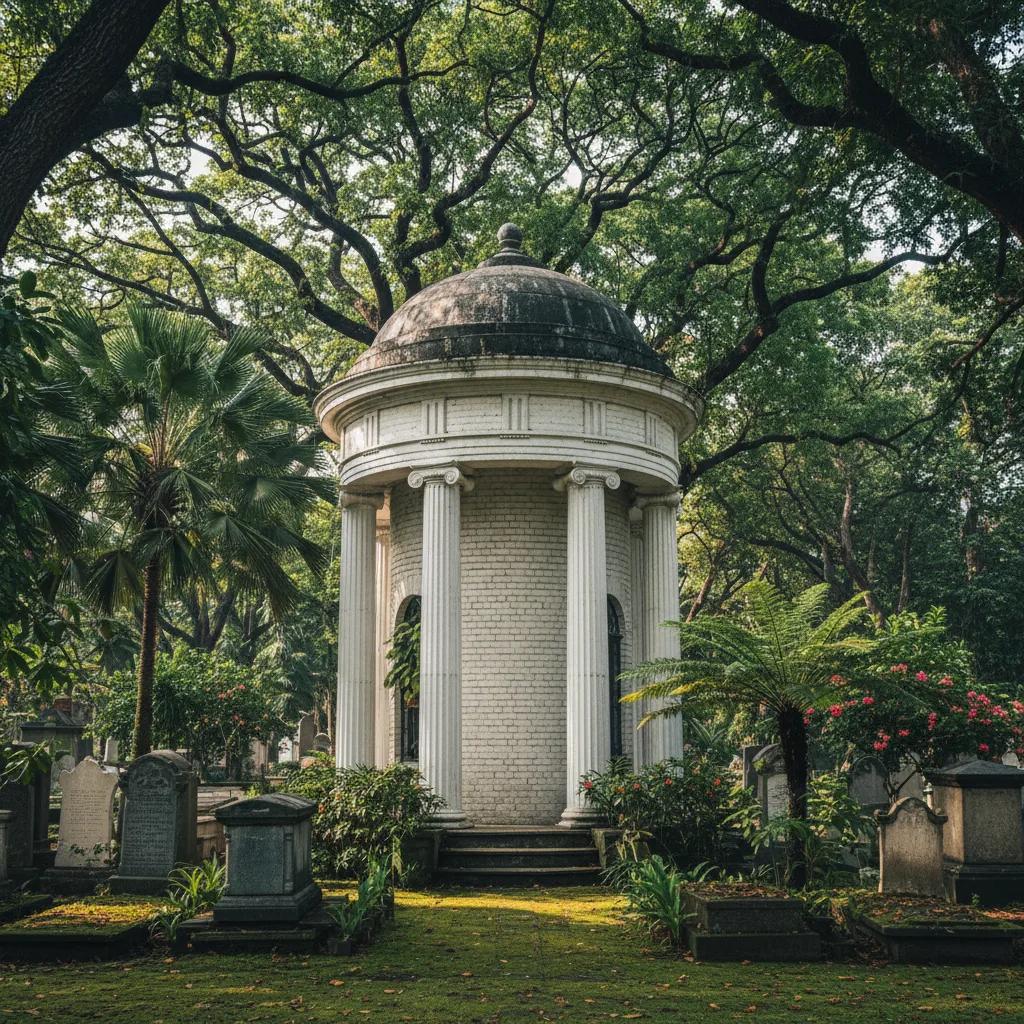
Architectural craftsmanship across the cemetery grounds is exemplified by two freestanding classical cupolas designed in the 1840s by government superintendent George Drumgoole Coleman. These circular masonry pavilions feature fluted Tuscan columns supporting domed brick canopies with plaster urn finials, providing classical memorial anchors within the tropical garden. The gentle contrast between pale European neoclassical masonry and spreading ancient rain trees creates one of the most evocative heritage atmospheres in Southeast Asia.
Maritime Navigation and Underground Bunkers
Climbing toward the southern crest of the hill reveals the Fort Canning Lighthouse, an elegant twenty-seven-meter octagonal steel tower erected in 1903 to guide maritime vessels entering Keppel Harbour. Perched prominently on the high ground overlooking Singapore's southern roadstead, the lighthouse featured a revolving dioptric lens visible across twenty nautical miles. While decommissioned in 1958 when surrounding high-rise buildings obscured its coastal beam, the slender steel structure remains a cherished relic of the colony's maritime navigation history.
Nearby along the elevated central ridgeline stands the Battlebox bunker entrance, leading into the bomb-proof underground headquarters constructed in 1936 by British Far East Command. Built nine meters beneath the earth with reinforced concrete blast walls, gas filtration chambers, and telephone distribution exchanges, this subterranean operations bunker accommodated key military staff during the Battle of Singapore. It was within these fortified underground rooms on February 15, 1942, that Lieutenant-General Arthur Percival reached the fateful decision to surrender Singapore.
Winding down the southeastern slopes of Canning Rise brings walkers past the historic administrative precinct, anchored by the Old Central Fire Station completed in 1908. Recognized as Singapore's oldest surviving fire station, this Edwardian building displays vibrant red-and-white striped brick masonry—often termed blood-and-bandage architecture—alongside rusticated carriage arches, classical pedimented dormers, and a prominent hose drying watchtower that dominated the civic skyline for decades.
Terraced Gardens and Passive Tropical Adaptation
Exploring the surrounding parkland terraces highlights Raffles' early vision for acclimatizing exotic agricultural flora to the Malayan climate. The recreated Spice Garden flourishes on the precise slope where colonial botanist Nathaniel Wallich established Singapore's first experimental botanical garden in 1822, cultivating clove, nutmeg, and cocoa trees. Brick-paved footpaths meander past fragrant spice trees and terraced stone retaining walls, illustrating how colonial agrarian enterprise directly shaped the physical topography of the hill.
Colonial masonry construction across Fort Canning displays deliberate thermal and structural adaptations suited to heavy tropical rainfall and intense heat. Retaining walls and drainage conduits constructed during the nineteenth century utilized porous red laterite stone and imported Scottish firebricks laid with natural lime mortar, allowing moisture to seep naturally without causing catastrophic structural collapse during equatorial downpours. Shaded earthen banks and dense tree canopies kept underground ammunition magazines naturally insulated from daytime heat.
Connecting the hilltop military network with the river below were strategic communication paths such as River Valley Road and Clarke Quay embankment stairs. Soldiers stationed atop Fort Canning could descend to the river wharves within minutes to inspect cargo, while semaphore signals hoisted from the hilltop mast relayed vessel movements directly to merchants in Commercial Square. This intimate operational link between the hilltop fortress and the commercial river formed the backbone of colonial Singapore's maritime efficiency.
Walking Route Strategy and Practical Tips
Strategic timing for this hilltop walking circuit focuses on early morning or late afternoon when ambient temperatures remain comfortable for walking up terraced slopes. Exploring between 8:30 am and 11:00 am allows visitors to take advantage of tranquil shaded paths and gentle breezes rustling through century-old heritage trees. Morning sunlight filtering through the dense banyan canopy casts dramatic shadows across the weathered stone arch of Fort Gate, offering exceptional lighting for heritage photography.
Pedestrian pathways throughout the park feature smooth brick paving, cobblestone garden ramps, and covered heritage rest pavilions that make walking across the varied elevations enjoyable. While some stone steps link the steeper terraces, continuous sloped pathways provide accessible detours for visitors seeking gentle inclines. Carrying drinking water and applying insect repellent ensures an uninterrupted and pleasant historical exploration throughout the lush tropical hilltop grounds.
Direct transit connectivity serves the perimeter of the hill with multiple entry gateways, including Fort Canning MRT station on the Downtown Line right at the foot of the hill, Clarke Quay MRT station on the North East Line, and Dhoby Ghaut MRT station connecting from the north. Convenient covered escalators rising from the Bras Basah and Dhoby Ghaut approaches allow walkers to ascend directly to the upper plateau without strenuous hill climbing.
Mapping your historical route through the greenery is made straightforward with digital heritage discovery resources. The Karpo APP provides intuitive topographical walking trails, GPS-aligned monument guides, and insightful historical notes that connect Fort Canning's military architecture with the surrounding civic and riverfront quarters. Walking the historic grounds of Fort Canning offers an unforgettable encounter with the defensive strategies, civic ambition, and tropical landscape design of nineteenth-century Singapore.
Ask Karpo for more information.
Keep reading
- Marina Bay Food Market Grazing Route After a Conference Day
 River Valley Food Market Grazing Route With Young Kids
 Serangoon Food Market Grazing Route for a Homecoming Weekend