 MiMo District Free Indoor Weekend Plan Finder for Retro Fans
Free Things to Do
Little Havana Scenic City Skyline Viewpoint Walk Guide
Follow a Little Havana scenic city skyline viewpoint walk from Calle Ocho to Jose Marti Park using Karpo APP to sequence riverfront overlooks.
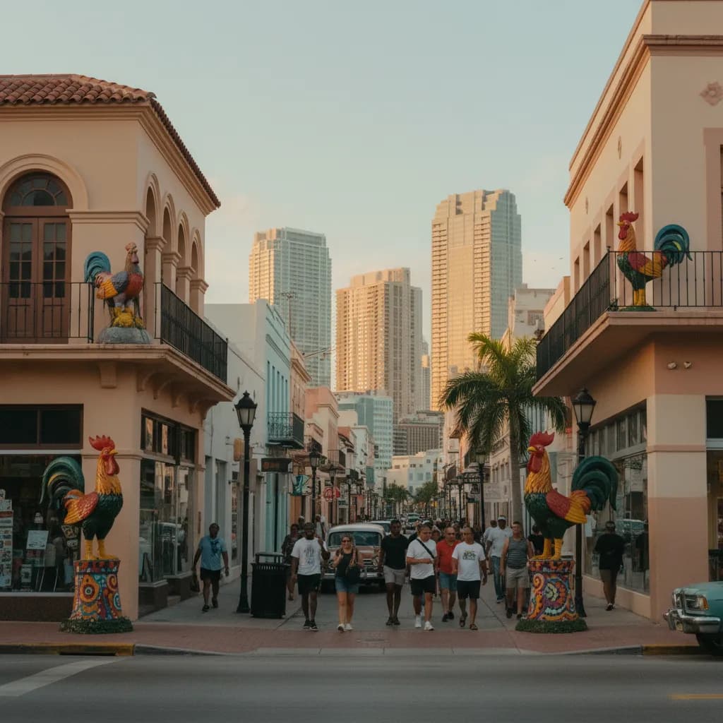
Looking straight east down Southwest Eighth Street from the corner of Southwest Fifteenth Avenue outside Maximo Gomez Park, the towering glass curtain walls of the Brickell financial district rise less than two miles away at the end of a low-rise corridor of tiled roofs, cigar shop awnings, and painted rooster statues. Discovering a scenic city skyline viewpoint in Little Havana hinges on this vivid urban juxtaposition between historic two-story neighborhood fabric and the vertical glass wall of Brickell and Downtown Miami immediately to the east. When you follow the eastern slope of the neighborhood down to the southern bank of the Miami River at Jose Marti Park, the street-canyon perspective opens into a wide waterfront amphitheater. Saving both the Calle Ocho corridor and the riverfront seawall inside the Karpo APP lets you trace the full transition from neighborhood plaza to river horizon.
Calle Ocho Eastern Axis And Maximo Gomez Park Sightlines
Between Southwest Seventeenth Avenue and Southwest Twelfth Avenue, Southwest Eighth Street forms the historic commercial spine of Little Havana, designated a National Treasure by the National Trust for Historic Preservation in 2017. Because the Mediterranean Revival and Art Deco buildings constructed along this corridor in the 1920s and 1930s rarely rise above two stories, the eastern sky channel stays completely unobstructed. Standing on the northern sidewalk beside Maximo Gomez Park, opened in 1976 at Southwest Fifteenth Avenue where neighbors gather daily over domino tables, aligns your camera lens straight down the avenue into the heart of the Brickell skyscrapers.
Late-afternoon sunlight streaming from the west illuminates the warm terracotta facades, hand-painted murals, and brass Walk of Fame stars along the sidewalk while turning the eastern glass towers of Brickell into a shimmering backdrop. Telephoto and fifty-millimeter lenses compress the two-mile distance so the modern supertalls appear to rise directly behind the vintage marquee of the 1926 Tower Theater across the street. Recording the intersections of Southwest Fifteenth Avenue and Southwest Thirteenth Avenue in the Karpo APP helps you capture the cleanest axial views along the boulevard.
Jose Marti Park Seawall Along The Miami River Channel
Walking east down Southwest Eighth Street or Southwest Seventh Street toward Southwest Fourth Avenue and turning north leads to Jose Marti Park, an eleven-acre municipal park opened in 1985 along the southern bend of the Miami River. Situated right where the river curves around the western flank of Downtown Miami and Brickell, the park features a wide paved riverwalk lined with royal palms, shaded benches, and a bust of the nineteenth-century Cuban poet and independence leader Jose Marti.

Standing at the northern seawall railing of Jose Marti Park places the entire glass skyline of Downtown Miami and northern Brickell directly across the hundred-yard river channel. Tugboats guiding cargo freighters upstream and water taxis cruising toward Biscayne Bay pass immediately in front of the waterfront towers, creating dynamic water reflections at golden hour. Neighbors walking along the breezy promenade and anglers casting from the stone bulkhead enjoy one of the calmest public riverfront perspectives in the city. Keeping the Southwest Fourth Street entrance to Jose Marti Park saved in the Karpo APP gives your walk a tranquil waterfront finale away from boulevard traffic.
Southwest First Street Bridge And Riverside Neighborhood Slopes
North of Jose Marti Park along the eastern edge of Little Havana, the bascule bridges at Southwest First Street and West Flagler Street cross the Miami River into the downtown civic core. Walking onto the western pedestrian sidewalk of the Southwest First Street Bridge, originally constructed during the 1920s bridge-building program and modernized for river navigation, lifts you twenty feet above the water surface for a sweeping diagonal view down the river canyon. From the center of the span, you can trace the historic concrete bridge tenders' towers alongside modern glass residential spires.
West of the river bridges along Southwest Fourth Street and Northwest South River Drive, the natural oolitic limestone rise of the Atlantic Coastal Ridge gives the residential blocks of Riverside and eastern Little Havana a subtle elevation advantage. Looking east between the historic wooden frame houses and porch roofs built before 1930 reveals the layered glass towers of Downtown Miami rising above the palm canopy. Adding the Southwest First Street bridge approach to your Karpo APP route notes lets you compare elevated bridge angles with the water-level park promenade.
Midday Heat And Heavy Traffic Blocks To Skip Plus Transit Backups
Skip walking the unshaded eastern transition blocks of Southwest Eighth Street between Southwest Tenth Avenue and Southwest Fourth Avenue at midday during summer months, when wide multi-lane commuter traffic heading toward Interstate Ninety-Five creates heat glare and roadway noise. Walk those connecting blocks along calmer residential streets like Southwest Fourth Street or Southwest Fifth Street, or schedule your outing during the ninety minutes before sunset. You should also skip crossing the Miami River drawbridges when warning bells sound for approaching freight vessels.
Whenever an afternoon rainstorm or humid summer squall develops, hop aboard the free air-conditioned City of Miami Little Havana Trolley or Metrobus Route 8 along Southwest Eighth Street, which connect directly east to the Brickell Metrorail and Metromover station and west through the cultural district. The covered entrance arcade of the historic 1926 Tower Theater at Southwest Fifteenth Avenue and the shaded pavilions inside Maximo Gomez Park provide immediate cover while you check your saved transit connections in the Karpo APP.
Sequencing A Plaza-To-Riverfront Sunset Walk
Start a ninety-minute Little Havana skyline walk at the corner of Southwest Sixteenth Avenue and Southwest Eighth Street two hours before sunset, strolling east past the 1926 Tower Theater and Maximo Gomez Park while the western sun behind your shoulders lights up the eastern Brickell skyscraper wall down the center of Calle Ocho.
One hour before sunset, turn north at Southwest Twelfth Avenue or Southwest Eighth Avenue to follow the quieter residential sidewalks of Southwest Fourth Street east to Jose Marti Park on the Miami River. Spend the final forty minutes of daylight along the riverfront seawall watching the Downtown Miami and Brickell towers turn amber and reflect across the calm river current. Reviewing this west-to-east sequence in the Karpo APP leaves you a short walk or trolley ride from the Brickell and Government Center transit hubs at dusk.
Ask Karpo for more information.
Keep reading
- MiMo District Free Indoor Weekend Plan Finder for Retro Fans
 Coral Gables Free Indoor Weekend Plan Finder for Book Lovers
 South Beach Free Indoor Weekend Plan Finder for Rainy Days