 MiMo District Free Indoor Weekend Plan Finder for Retro Fans
Free Things to Do
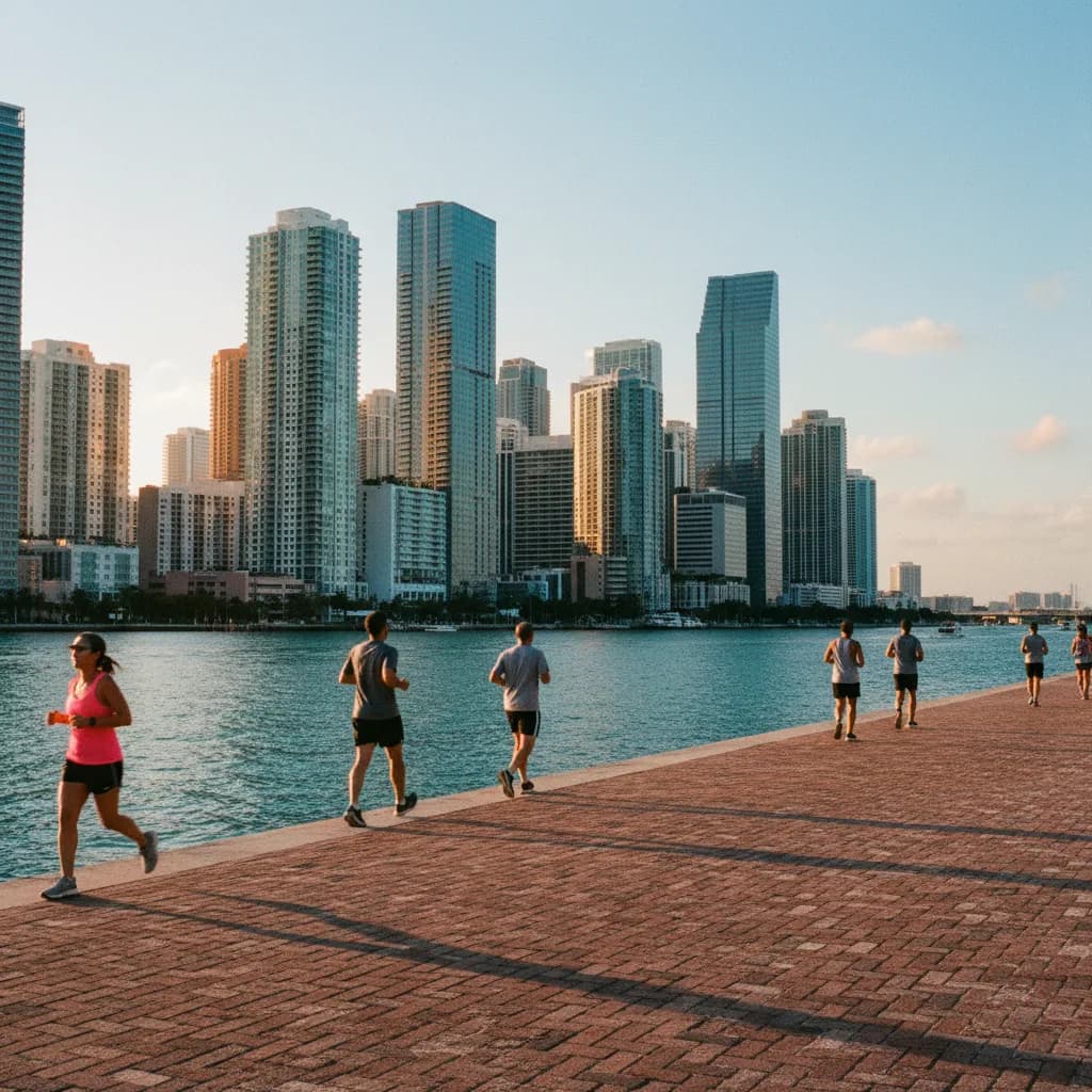
Brickell Miami Scenic City Skyline Viewpoint Walk Guide
Explore a Brickell Miami scenic city skyline viewpoint loop around Brickell Key and Miami Circle using Karpo APP to sequence bayfront stops.
Crossing the short arch of the Brickell Key Bridge off Southeast Eighth Street and stepping onto the western seawall of Claughton Island, you suddenly stand across a narrow channel of turquoise water with the entire vertical glass wall of the Brickell financial district rising directly in front of you. Finding an unobstructed scenic city skyline viewpoint in Brickell means stepping just outside the dense canyon of Brickell Avenue onto the island loops, river mouths, and causeway ramps that ring the shoreline. Because standing directly beneath seventy-story towers on the main avenue limits your camera angle to narrow slices of sky, moving out to Brickell Key and Brickell Point gives you the distance needed to take in the full architectural profile. Using the Karpo APP to connect the island baywalk with the Miami River mouth lets you trace the waterfront in one continuous loop.
Brickell Key Perimeter Baywalk And Financial District Reflections
Originally formed from two spoil islands dredged in 1943 by developer Burlingama Claughton and transformed into a master-planned triangular island beginning in the late 1970s, Brickell Key is encircled by a continuous one-point-two-mile public pedestrian promenade. Walking along the western brick-paved seawall immediately north and south of the Brickell Key Bridge places you just across the water from the Brickell Bay Drive towers, allowing wide-angle lenses to capture the entire skyline from foundation to roof crown.
As you round the northern apex of the island where the Miami River empties into Biscayne Bay, your horizon expands northward to frame the curving sail-like glass facade of the Aston Martin Residences, the historic 1925 Freedom Tower in the distance, and the cruise ship terminals of PortMiami. Evening runners, local residents walking dogs under the coastal palms, and architectural photographers share the wide brick walkway, which is completely separated from vehicle traffic. Saving the Southeast Eighth Street bridge approach inside the Karpo APP anchors the centerpiece of your Brickell skyline route.
Miami Circle At Brickell Point And The River Mouth Drawbridge
Walk west off the island along Southeast Eighth Street and head north up Brickell Avenue to reach Brickell Point on the southern lip of the Miami River mouth. Here, a quiet two-acre public lawn surrounds the Miami Circle, a thirty-eight-foot prehistoric oolitic limestone foundation carved by the indigenous Tequesta people, uncovered by archaeologists in 1998 and designated a National Historic Landmark in 2009. Standing at the northern riverfront railing beside the lawn gives you a dramatic water-level perspective looking straight across the river channel into the heart of Downtown Miami.

Immediately west of the park rises the Brickell Avenue Bridge, a twin-leaf bascule span completed in 1995 and crowned by a bronze monument honoring the Tequesta family. Climbing onto the eastern pedestrian sidewalk of the bridge lifts you above the riverboats and freighters navigating the channel while framing the soaring glass canyons along both riverbanks. Recording the Miami Circle lawn and the eastern bridge sidewalk in the Karpo APP lets you transition smoothly from wide bay vistas to dramatic river-canyon angles.
Rickenbacker Causeway Pedestrian Path At The Southern Edge
At the southern end of Brickell Avenue where it merges toward South Miami Avenue and the bay, walkers who want a high southern vantage point can follow the dedicated pedestrian and bicycle sidewalk up the western approach bridge of the Rickenbacker Causeway. Opened in 1947 to link mainland Miami with Virginia Key and Key Biscayne across Biscayne Bay, the elevated western bridge climb lifts your line of sight high above the shoreline mangroves and yacht basins. Concrete safety barriers separate walkers and cyclists from the causeway lanes all the way up the bridge arch.
Looking back north from the first bridge crest reveals the entire Brickell skyline stacked like a crystalline peninsula between the green canopy of Coconut Grove to the west and the open waters of Biscayne Bay to the east. Nearby at the base of the corridor, Simpson Park Hammock, preserved since 1913 as a fragment of native tropical hardwood hammock along South Miami Avenue, offers a shaded botanical counterpoint to the surrounding steel and glass. Keeping the Rickenbacker approach as an optional southern extension in the Karpo APP gives energetic walkers a commanding elevated overlook.
Drawbridge Openings And Midday Glare To Skip Plus Metromover Backups
Skip crossing the Brickell Avenue Bridge during weekday evening rush hour between five and six-thirty if you are on a tight schedule, as periodic bascule bridge openings for tall river vessels halt both vehicle and pedestrian crossings along the span. You should also skip the unshaded eastern seawall of Brickell Key at midday during July and August when tropical humidity and intense water glare peak, choosing the final hour before sunset when the western Brickell towers cast cool shade across the island channel.
Whenever a sudden tropical downpour or gusty thunderstorm rolls across Biscayne Bay, walk two blocks inland from Brickell Avenue to board the free elevated Metromover Brickell Loop at the Eighth Street, Tenth Street Promenade, or Financial District stations, or connect directly to the Brickell Metrorail station opened in 1984. The covered multi-level climate-ribbon walkways of Brickell City Centre along South Miami Avenue also provide dry shelter right beside the Eighth Street Metromover platform while you consult your saved route notes in the Karpo APP.
Sequencing A River-Mouth To Island-Loop Sunset Walk
Begin a ninety-minute Brickell skyline walk at the Eighth Street Metromover station two hours before sunset, walking east to Brickell Avenue and north to the Miami Circle park lawn at the mouth of the Miami River. Spend twenty-five minutes along the riverfront railing and the eastern sidewalk of the Brickell Avenue Bridge while late-afternoon light illuminates the northern downtown towers across the water.
One hour before sunset, stroll south down Brickell Bay Drive and cross the Brickell Key Bridge onto Claughton Island, following the public baywalk counterclockwise from the eastern Biscayne Bay shoreline around the northern tip to the western seawall. As the sun sinks behind the mainland, the glass curtain walls of Brickell glow amber and violet across the narrow channel right in front of you. Checking this loop in the Karpo APP keeps your return walk to the Eighth Street or Tenth Street Metromover station simple.
Ask Karpo for more information.
Keep reading
- MiMo District Free Indoor Weekend Plan Finder for Retro Fans
 Coral Gables Free Indoor Weekend Plan Finder for Book Lovers
 South Beach Free Indoor Weekend Plan Finder for Rainy Days