 Los Feliz Nail Salon Walk In Finder for Broken Nail Repair
Neighborhood Guides

Heritage Historic District LA: Read Carthay in 3 Scales
Read Carthay Circle through roof forms, street space and its vanished theater story, keeping a public-sidewalk walk distinct from private house visits.
Carthay Circle was planned as a community, not simply a collection of houses. City Planning describes J. Harvey McCarthy's development as combining housing with civic, commercial and entertainment ambitions. For a heritage historic district visit in LA, that history suggests three scales of attention: an individual roof, the space of a residential street and the memory of the former theater. These scales ask different questions. You can explore them from public sidewalks without booking a house tour or treating the neighborhood as an outdoor film set.
The theater explains a name, not a surviving attraction
The former Carthay Circle Theater helps explain the neighborhood's name. The city's history connects the change from Carthay Center to Carthay Circle with the theater's circular auditorium and tower dome. That is a historical relationship, not an invitation to seek a functioning theater at the end of the walk. Begin by separating the story of a lost building from the buildings that remain available for exterior observation. Otherwise a useful piece of context can quietly become a misleading destination.
You do not need to reconstruct the auditorium to use this story well. Think about how an entertainment building can give a residential neighborhood a recognizable identity, then look for what carries identity at the scale of a house or street. A repeated material, a roof profile or the spacing between buildings may do the work now. This comparison keeps the vanished theater in the historical account while allowing the visit itself to be grounded in things actually visible.
Read a roof as a complete shape
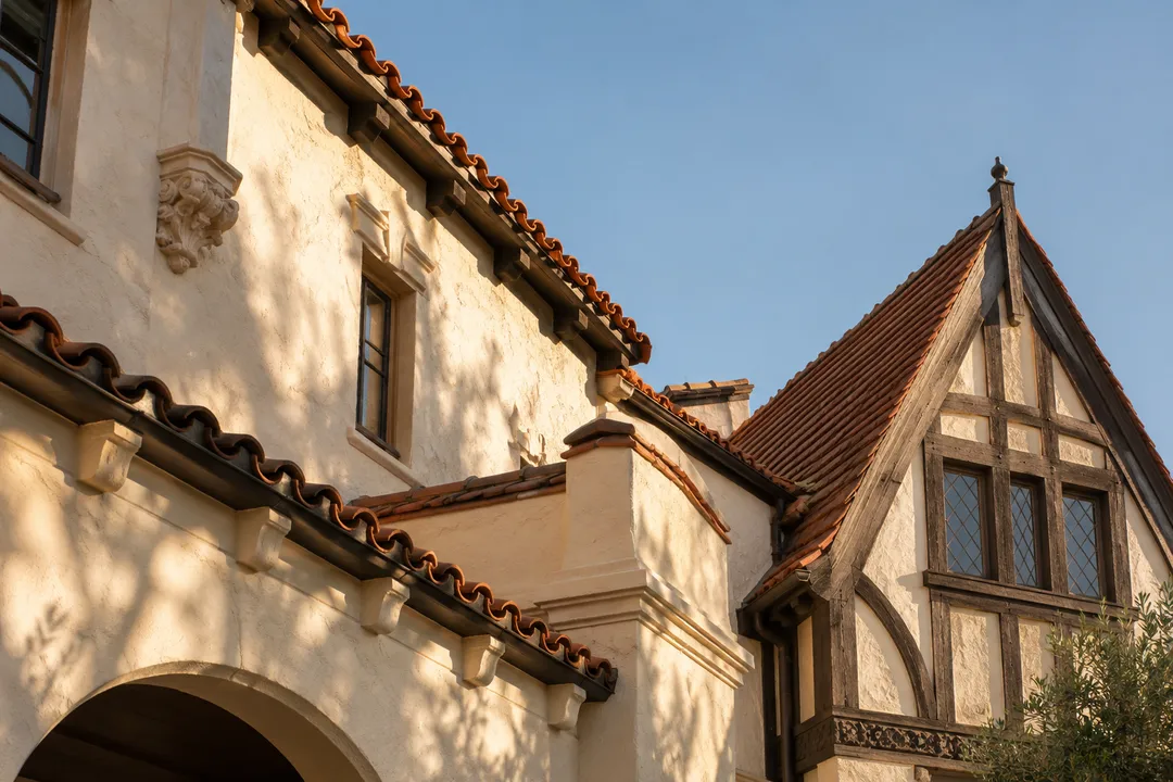
Spanish Colonial Revival is the dominant architectural style identified by the city, with Tudor, French and American Colonial Revival examples also present. Start by looking at roof profiles rather than treating every red tile as a complete style diagnosis. Follow the pitch, the depth of the eave and the meeting of roof and wall. Where planting leaves the frontage visible, compare the roof's width with the height of the facade beneath it. Proportion often communicates more than a decorative detail photographed alone.
Next, find an example with a visibly different outline. A steeper gable can offer a useful comparison with a lower tiled roof, but describe the actual forms before applying a label. An altered roof material or a recently painted wall does not establish a building's original appearance. A careful note can say that the gable is steep and the entrance recessed without claiming an architect, a construction date or a restoration history. Those claims require a property record rather than an impression.
The spaces between houses are part of the composition
Step back mentally from the individual frontage and notice the intervals. A gap between roofs, a garden visible from the pavement and the setback of an entrance can give a street a rhythm. You are looking at relationships rather than measuring parcels. The nearest house might feel imposing in a tight photograph yet sit comfortably among neighboring buildings when seen in context. Make one wide sketch that includes two frontages and the gap between them to test that difference.
This is a better exercise than ranking homes by size or presumed value. Architectural variety does not reveal the present occupants' income or the arrangement of rooms behind a facade. Keep your observations at the exterior scale: mass, spacing, roof and planting. If a hedge hides one house almost entirely, leave it out of the comparison. The district still has an identity when a resident chooses privacy, and your walk does not need to overcome that choice to succeed.
An uncluttered skyline had a planning history
The city's account identifies underground utilities as an early feature of Carthay Circle's planning. Use that documented intention as a prompt to examine the upper part of your street view. What occupies the space between roof and sky? Compare the visual emphasis of trees, rooflines and any infrastructure you can actually see. Do not turn a historical planning distinction into an assertion that every wire across the wider area is absent today. Record the particular view rather than expanding the claim.
Try framing the same stretch twice: once with the pavement and garden edge included, then with attention on roofs and sky. The first image emphasizes how houses meet the street. The second may reveal which roof forms dominate the group. Neither is the correct photograph, and neither by itself tells the whole planning story. Together they give you a more precise account of why one street feels visually coherent despite differences between individual houses.
Keep three Carthay names separate
Carthay Circle, South Carthay and Carthay Square are separate district subjects in the city's preservation system. Their similar names can make a casual walk seem more geographically definite than it is. Use the relevant city map for the properties you want to study, particularly if your notes concern designation or a contributing building. A pleasant residential connection between areas should be described as an extension, not silently included inside the Carthay Circle boundary.
For this outing, choose a small mapped portion of Carthay Circle and keep the roof-and-street comparison together. Skip a long detour undertaken only because another place has Carthay in its name. It will blur the topic unless you intend a separate comparison of the districts. A friend interested mainly in cinema history may prefer the theater story, while a companion who likes drawing can focus on the roof pair. They can share the same outing without forcing identical interests.
Practical Notes: a residential walk with a clear endpoint
Plan to remain outside. This article gives no access arrangement for homes, institutions or former entertainment sites, and no claim about business hours or refreshments. Keep driveways and doorways unobstructed. If traffic or a narrow pavement prevents a safe wide view, choose another observation position instead of backing into the street. The editorial goal is a legible comparison, so a partially obscured example can be replaced without spoiling a route or missing a required attraction.
Finish by writing three different captions: one about a roof, one about the street space, and one about the theater's role in the name. Each caption should contain a distinct observation or documented historical point. You may ask a general neighborhood question in the Karpo APP, but this piece does not claim live access checks or guided-tour reservations. Its accompanying images are AI architectural composites illustrating forms, not records of named Carthay Circle houses. Keeping that distinction clear lets the historical context support the walk without substituting an invented view for the neighborhood.
Ask Karpo for more information.
Keep reading
- Los Feliz Nail Salon Walk In Finder for Broken Nail Repair
 Highland Park Nail Salon Walk In Finder for Retro Manicures
 Koreatown Nail Salon Walk In Finder for K-Beauty Nail Looks